Goddard Space Flight Center 12:30 p.m.
Charles Gatebe:
I’m calling in from my office at Goddard Space Flight Center today. We finished our flights for CAR yesterday, on Monday. I did try to call in my report late in yesterday evening as I was driving home from Wallops. I missed the connection at that time – but today’s a good time to catch up.
This has been a hectic, hectic time for me. I came back to my office to work today for the first time in at least a month. We’ve been flying that long! Before that, I was working on getting the instrument on the aircraft, so it’s been more like six weeks since I’ve done much work in the office. I did stop in from time to time, between flights, but only for an hour or two. So now I have plenty of office work to do here!

Flight campaigns are very long and very busy. Work for the campaigns start weeks before the flights themselves. To get ready to fly, you first have to have your instrument ready. Then you integrate the instrument into the plane. When you think that is done, then you let the pilot fly with the instruments all loaded, to make sure that they don’t fall down in takeoff, landing or flying. Then you finally get to go and check the instrument itself to see how it performs in flight. So when a flight campaign lasts a month, you can be sure that the work started well before that time.
We started very early in the morning yesterday and had a really long and really good day. I left from my house in Silver Spring at 3 a.m. and then drove to Wallops, which is over 3 hours away. After the flights, I drove home the same day and arrived about 7 p.m. Friday was worse, I flew 8 hours, left home at 3 a.m., and then drove back home after that flight. It was a 14-15 hour day on Friday.
Yesterday, we had wheels-up at 8 a.m. Once we were in the air, we flew a few lines over Wallops, then made one more run for SIMPL, and then we headed out to Massachusetts. We made good measurements under clear skies there all morning. The site in Massachusetts is Harvard forest, and we had identified it as a backup site, early on. It wasn’t a primary site, but it was a place we wanted to fly if we could. Finally we got the chance.
Our first choice yesterday would have been to fly directly to Howland, but we heard it might be very cloudy there, which isn’t good for CAR or SIMPL. Because Bartlett Forest is fairly close to Howland, we thought the cloud cover might extend out there early in the morning, too. That’s why we decided to go to our backup site, Harvard Forest, which was predicted to have clear skies. And it did – the skies were nice and clear.
We made a lot of measurements for SIMPL over the forests, and then we went to the Harvard Tower to take measurements for CAR. The tower is a flux tower in Harvard Forest that was installed in 1989. It has instruments on it which can provide a long-term record of net ecosystem CO2 exchange, evaporation, and energy flux (energy change). They can make measurements hourly. So it’s an interesting and well-studied site.
Because we wanted to make our measurements over that tower, I had the pilot circle the tower there while CAR acquired data. I guess it must have looked like we were hovering over the tower, and we were there long enough that apparently people started to notice us flying not-too-high in a clear blue sky over their heads. We made the newspaper in a local town, and a photographer took a great photo of the P3 at work.
When we finished our measurements at Harvard Forest, we flew to Bartlett to see if we could make measurements there. We had lost our earlier chance at Bartlett, in New Hampshire, because the hurricane made us leave early. When we got there, we found the sky to be very clear, and we were able to fly our mission and acquire very good data there, too. It was very nice – I really enjoyed going there and finding no clouds in the sky. About the time we finished making our measurements, a few cloud cells began to form, but that wasn’t too bad. We had finished what we wanted to do. And so that was when we headed straight back to Wallops – and we were done with measurements for this flight campaign.
We had about 6 hours of flying time yesterday. That’s long enough to fly from coast to coast, isn’t it? But instead of going from one coast to another, we made measurements instead, mostly flying lines and in circles. Sometimes you don’t realize how long you are flying when you are working, because you are very busy making sure the instrument is collecting good data and making observations. It seemed like a very long day at the end, but while working, the time seemed to go fast.
It is very intense when you are flying a science mission. It is like you are in a laboratory. You want to be alert and making observations the entire time, so that later on, when you analyze the data, you can tie the observations into the measurements the instrument has collected. The entire time we are in the air, I am making notes. When I am doing the analysis, I can go back and tie the data back to what I noted. Also, I take a lot of pictures. They will all be time-tagged, so you can look at the log, the data and the photos and know what happened at what time.
When I fly, I sit in a bubble window. At my station, I have the computer and the window, too, because I really need to see where we are flying. I want to be able to know if there are clouds or the sky is clear, if we are flying over buildings or what the ground might look like. I also am able to talk to the pilot. Sometimes I can see things he doesn’t notice. If we are flying into thin clouds, for example, the pilot might not notice and keep flying into them. I can call him and ask him to go elsewhere.
It is a busy, busy, busy time in the air. I tell my students that it’s not just a good time. You must make observations. You must note issues or problems that arise. It is so important to be curious. That’s how things are discovered – and there is so much to be discovered!

Let me give an example. There was recently a study published – an interesting study – that began from an unexpected observation. We were over the Pacific Ocean trying to gather data for an experiment that wanted clear skies. But we kept flying into ship plumes – and those plumes affect the instrument. Toward the end of that experiment, the skies over the ocean appeared beautifully clear and I asked the pilot to orbit over that clear area. I started making measurements, with no ships in the area, and was very, very happy. I said that it was a good, classic experiment and that was excellent.
Then I looked and there was a ship plowing through the area of my measurements. I wasn’t happy, but I kept collecting data. And I made careful notes – when the ship appeared and when we it left the area. So when the data was being analyzed, my Quality Assurance person came and showed me some bad data – there was a huge increase in albedo. I say, “This isn’t possible” and the QA people said, “But that is what the data says”. So we thought we had a serious problem with the data. We went and matched this to the log, and found that the big, surprising increase in albedo was caused by that ship itself – it wasn’t bad data. It was an important observation.
So we saw that the wake of a ship makes the ocean tremendously brighter – over 100 times brighter than clear ocean. I made that observation while collecting data, and if I hadn’t we would have missed an important finding, one that has led to a second study. It’s observation that leads you to other things. I emphasize to my students, when they get to come on a flight, that this is no honeymoon – it is hard work. I want to stay focused, stay busy and make notes. There are so many things that need to be discovered out there. If you don’t pay attention, then you don’t see it.
I like to think of my instrument as a set of eyes. CAR is measuring radiation in the ultraviolet, the visible and the near infrared frequencies. This instrument can “see” things that our eyes can see, and so much more. So imagine having that set of eyes – you are looking and observing with amazing power, when you have those kinds of eyes. So I need to compare my own eyes with the instrument eyes – UV, visible and near infrared. I can use my own eyes to help interpret what we see. When we look at the data, we see that some objects may seem to reflect one part of the light – or absorb it – much more strongly that we would expect. And that type of thing is what we want to capture. When you find something unexpected, it’s phenomenal.
So that’s the main point I want to make. It’s important to be very, very observant.
We had some instrument issues on this flight campaign, especially with the DBSAR which is fairly new. For me, I am flying an instrument that has flown for many years, so there are not so many surprises with CAR.
The biggest challenge, when we set out, was that we had very low expectations of what measurements we would take. We thought we’d measure just Howland, maybe Wallops, but not a lot more. But we had the opportunity to gather a lot more data. We did get our measurements over Howland, but we also took in New Hampshire and Massachusetts sites, and others. Many of these sites have on-going measurements, and that will help us make very strong conclusions about our data. When we went to Florida, we realized that those sites were really very, very interesting, too. So from low expectations, we rose pretty high and have had a very successfully campaign.
I did have one big surprise with the instrument. At first, it was failing all of the check flights. It never fails check flights – I know this instrument, and it works well. It shouldn’t fail any check flights. But it failed so bad, that they just about dumped me from the mission.
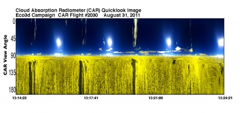
So let me tell you about my instrument. It rotates almost 360 degrees. It sits on the nose of the plane, and with this 360 degree rotation, I can observe the skies anywhere. I can see a cloud at any angle at all. When we are on a flight, I start with an objective. Sometimes I just want to look at the surface of a cloud, or I’ll want to look just at vegetation, I will move it around. I can sweep from one side to another and get a view almost like a carpet – it is a fantastic view.
The part that moves the instrument, there is a collar on it to control the movement. When the pilot was doing the flight checks, he felt uncomfortable. He thought that he might not be able to control it. And he thought it was my problem. And they were going to take me off the flight – no work at all. That was August 19, when they said we couldn’t pass the flight test, and so we couldn’t fly.
But I said no, it wasn’t my instrument but that collar that they added. I know this, because we have never failed a flight check before. It took quite a lot of convincing, but we took the collar off and it was fine. We were able to demonstrate that the instrument was harmless. And so we were back on the flight – it was close, but we made it!
The only other surprise was that halfway through the fights, the instrument broke down. I could not find out why. I was sure it was in the wiring. So I spent a long two or three hours in the air, looking at every wire and troubleshooting everything I could find. I couldn’t find anything there. But on the ground, I found there was something small wrong in the instrument itself, and I got it fixed really fast. That was a very happy moment for me!
Now, I have some pictures I’ll post on this blog. But if you want to read more details about the CAR instrument, and more details about the campaign, we have a website. There you can see the instrument as well as each of the campaigns. The site is car.gsfc.nasa.gov. When you go there, you can click on Data, and then find Eco3D. Then you can go to each flight day and see our map (the lines we flew), our log, photos from the flight as well as data we acquired. Not all of that is up yet, but some of it is and we will be adding to the website just as soon as we get the data processed.
Well, this is the end of the flight campaign. We flew over just over 69 hours in four weeks – at the end of the day yesterday that was the total. My instrument went through that with only very minor issues, and we survived very well. All in all, we only lost about two or three hours of data. So it was a very long campaign, but very productive. From here, we go on to analyze the data. That is a great deal of work, too, but I am looking forward to doing that work, too.
Maryland 8:00 p.m.
Rafael Rincon:
I am calling from the Bay Bridge in Maryland, on my way to Goddard after a long day at Wallops. I’m almost there, after the final flight for the DBSAR on this campaign. It’s been a very long, but a very good day. The DBSAR worked beautifully, with no hiccups and no problems. For us, everything went just as planned.
We left early this morning from Wallops, Virginia and first we flew the DBSAR in New Hampshire. It was too cloudy to fly the lidar (SIMPL) there, so after we acquired our data, we continued to Howland. We acquired data for the DBSAR over the flight lines we previously flew there. And it was just perfect.

If you remember, when we flew over Howland early in this campaign, we had a problem with the RAID and we lost chunks of data there. When I looked at that data, it looked like there might be a chance that some of the data might end up unreadable. I think I can get it all, but I just am not sure. Since we had a chance to do so, we decided it would be a good idea to go back over those lines and collect that data again. Now we are absolutely sure we have excellent data over that area, and that’s really important to us.
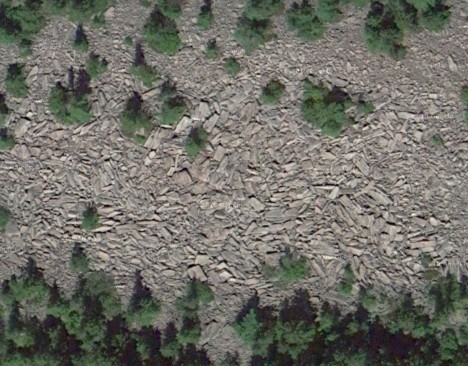
We also flew over the boulder field today, like we wanted to do earlier, and I think the data from there is just what we needed. We made 7 passes – we flew three lines and then the offset lines. After that, the clouds began to form and we had to hurry to get the lidar their chance at their flight lines. The data looks really good so far, and we’re happy with it. It actually is a small field, and it’s surrounded by forest. It’s an interesting location, and not like anything else we’ve sampled.
So we have completed everything we wanted to do from the DBSAR this campaign. Despite all the troubles with the RAID, the earthquake, the hurricane, the tropical storm, the trouble with the aircraft and issues with permissions in Canada – despite it all, we accomplished our mission and we have acquired the data we’d hope for.
It’s a very good thing that we built in a whole extra week – a contingency week – in case we had trouble. With a field campaign, it’s good to plan for the unexpected. We had that room, and we were able to work around all the challenges.
Today is the last flight for the DBSAR on this campaign. We have what we need, and there is no reason to take Monday to go back in the air. CAR and SIMPL have three hours left of flight time, each, I believe, so they may fly on Monday to use all of their time. They had cloudy conditions for some of the flights, so they still have a little they’d like to accomplish. I’d expect them to fly one more time, if the weather cooperates. We’ll know about that over the weekend.
When we landed tonight, I took a couple of hours to disconnect all of the cables that I could and worked to gather up everything I could to bring back with me tonight. When the missions end on Monday, the aircraft must be gotten ready for a different campaign right away, and that means all of our equipment must be out of the plane without delay. I don’t want to drive three hours back to Wallops on Monday, just to take my equipment home, and then drive three hours back. So I stayed and took care of most of it tonight. I left the big rack, but we’ll get that later. I have the power supplies, data devices, computers and everything else I could carry in my car, now.
So now what happens? Well, for DBSAR the flight is over, but now I have all of this data to work on. That means a lot of time in the lab, working to analyze the data. If it was just me working on this alone, it would probably take a full year, maybe more, to go through and analyze the data we collected from the DBSAR on this campaign. Of course, we have other people to help, so if we distribute it among others, it will take a bit less time to finish all the work on the data.
We’ll approach the analysis by prioritizing the data we want to study. We’ll pick key places at each site, places we know well and have a lot of associated data for, and I’ll analyze those places first. Then I’ll be able to see what we really have, and we can compare it to the other data.
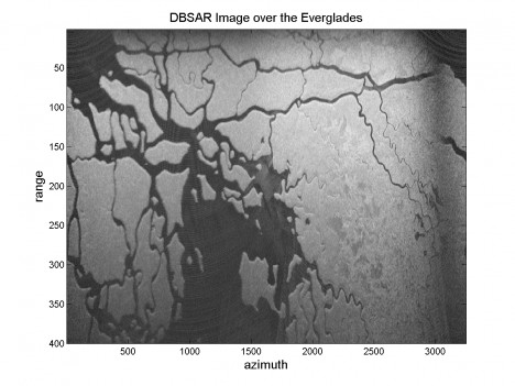
By working only the key sites, I think it will still be two to three months before we get the first set done. I’m really interested in taking a look at the Everglades sites, as well as the boulder field, so I know we’ll be looking at those pretty soon. I’ll work on the DBSAR quick view of the Everglades right away, and hope I can send it to be used in this blog, so everyone can see it.
Today’s flight is the end of the campaign for DBSAR. Despite all the hard work, long hours, and all the problems we encountered it is very rewarding to know that we were able to accomplish all our goals. I’m very glad with the way the DBSAR, SIMPL, CAR, and aircraft teams interacted, supporting each other, and working together towards a successful campaign.
Our next step is do great science with the data we acquired. I have a computer full of excellent data, and will be getting to that work right away.
Maryland 10:00 p.m.
Rafael Rincon:
Today was a really good day – things went really smoothly and we successfully acquired a lot of good data without any glitches. The flights today were over the Everglades and the Florida keys. It was very scenic, and I wanted to get some pictures out the window but I was really busy with the instrument so I didn’t get a chance to get to the camera!
We flew over the Everglades yesterday, too. Both days we had clear sky in the early morning, so the conditions were ideal for both SIMPL and CAR. They made their measurements almost all morning, from 8 am – 11 am and were very happy with the outcome. DBSAR did fine today – no problems at all. It was a very successful two days for all the instruments.
This campaign to Florida has been the best for DBSAR and SIMPL as well. We have been able to collect a really great data set from both of the instruments. When we analyze the data, we should be able to put the data from the two instruments together to make some very good science. We have a lot of data to analyze and I’m looking forward to it.
Besides collecting a lot of data, we have learned an awful lot about the instruments in this campaign. We learned what the issues are and how to fix them. We are getting better with every flight, and it’s very satisfying.
Yesterday DBSAR ran an excellent campaign, with only very minor computer glitches and then only at the very end. Just when we were almost done yesterday, the RAID began to have a few hiccups. But I think I understand the problem fully now. It’s just that when the RAID fills up, it can’t run well and we start dropping data.
Originally we started with different type of RAID. At first the original RAID would lose a whole lot of data due to vibration. So when we started to fly, we’d get a lot of vibration, and then we’d lose the RAID, and when you lose the RAID, you can’t catch the data.
When we are collecting data, that data is coming in really, really fast and we need that RAID – a computer alone just can’t handle that much data coming in that fast. So when we saw the problems with vibration in the first flights, we went out and bought a new hard drive and configured a brand new RAID. It did pretty well – it would run for quite awhile but still have had some trouble as it filled up.
Because vibration was a problem in our first flights, when we had some downtime last week, we took the time to move the computer rack to a different part of the plane, so that we could minimize vibration. We did that – and it has helped tremendously. We can run the DBSAR for several hours with no problems at all. This new RAID is a whole lot better that the first one, but still, it will eventually fill up. When it does, then we start getting similar symptoms and can end up with some data losses.
But even though we still have some hiccups in the instrument under some extreme conditions, this campaign has allowed me to understand it better. So I know how to acquire data with the new raid without losing any data at all. Basically, I have a good idea how long the instrument will perform perfectly, so we can constrain our data collection to that amount of time. After that, we stop and empty the RAID completely and it will be ready to go again. We know now how to keep data collection to an optimum, and it’s great to know that.
We do have an upper limit to how much we can collect without problems. That’s not unusual and what’s most important is to know that upper limit. We know it now – it’s over 500 gigabytes, and that’s a whole lot of data. To get an idea of how much data that is, let me just say that it takes me about 10 hours just to download all of that data from the flight computer into a backup storage system. It’s a lot of data.
I want to mention that we have a new team member on this flight. He’s new to the flight campaign, but has worked with me at Goddard on this instrument for a long time. His name is Steve Suefert and he’s a technician here at our branch, working in the anechoic chamber where we calibrate the instrument before we fly, so he really knows the DBSAR very well. We weren’t expecting to fly this week, so not everyone could come along. Steve was willing to fill in when other people couldn’t come. Having him here has been great – he’s been a big help and the work has gone much faster than if I was trying to do this alone.
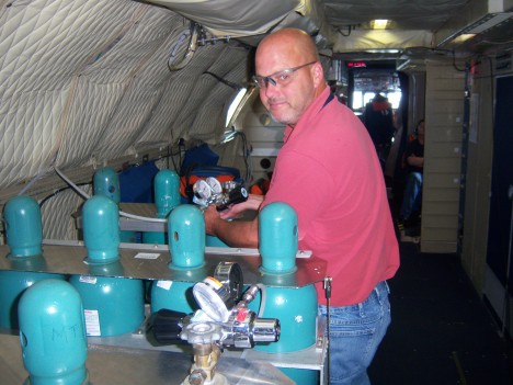
I’m sending a picture of him, and in that picture you see him standing near several gas tanks. They hold compressed nitrogen. We use compressed nitrogen to cool the instrument. We pump it through some specialized tubes, vortex tubes, to cool the air inside the radar. Also we use nitrogen to purge the system as we descend. When we fly, the air at high altitudes is very cold. When we descend the cold metal of the instrument comes in contact with the warm air at lower altitudes. The air is moist, so the temperature change means that condensation will form on the enclosed surfaces of the radar. You can imagine that condensation – water – isn’t very good for electronics at all, it can really mess it up. But we can stop the condensation from forming. The compressed nitrogen is very dry, so when we descend, we pour a lot of it into the system. By pouring in this very dry gas, we can keep the instrument dry. So we do that every time we descend.
Our plan had been to fly locally near Wallops tomorrow, because the weather isn’t going to be very good in Florida or in Pennsylvania. Also, the weather around Howland and Bartlett forests won’t be good – rain and clouds are forecast. We still have 14 hours of flight time and we want to use it. And we can gather good data at several sites near Wallops. So a day local to Wallops would be wonderful.
With that in mind, we transited from Florida to Wallops, finished our flights and after gathering what we needed from the airplane and shutting down the mission for the day, we headed out to our hotel room. When we arrived at the hotel, we heard new that changed everything. The flight crew from Wallops had called, and left a message that the aircraft had a problem. And that means we can’t fly tomorrow.
We have been told that the problem is small, and it’s not going to scrub our whole mission. But tomorrow they need to work on it. They are sure that the problem will be fixed by Friday, and we can leave then.
We only have the plane until Friday as it stands now. They tell us, however, that they may be able to extend the flight time until Saturday, to try to allow us to use our full 14 hours of air time. We’ll see what we can do. We need to fly, but Saturday means a lot of additional costs, with overtime and all of that. We’ll see. Another option might be to fly Monday. As it stands now, we have to de-install everything on Monday, so we can’t fly. But Wallops is saying they may be able to work with us to try to allow us to use our hours.
Since we aren’t flying tomorrow, I’m heading back to Goddard now. I have a lot of work to do and can use some time in the office. I also have to download the date from the RAID tonight. It takes about ten hours to download the data, but I can just start it and let it run all night.
We will have a teleconference at 2 p.m. tomorrow, and we’ll find out if we can go Friday. And if we can go, then I will leave from Goddard and drive back out to Wallops tomorrow afternoon and get ready for the flight. If we fly Friday, it will be a super long day in the air, to use all the hours we can and gather as much data as possible. Then we have to drive back home, so everyone will be working a 12- 14 hour day. This field campaign is really a lot of work, but that’s just the way they are. This one has paid off very well – we’re getting all of this excellent data and all of the experience with the instruments – it’s been really great.
Homestead, Florida 7:35 a.m.
Rafael Rincon:
Good morning! It’s early here, but we have been working already for a few hours. I’m standing outside the airplane, and we are getting ready to board for today’s flight. We made sure that everything is in place, and we are ready to go, as soon as they call us inside the plane.
I missed calling in last night, and I hate that. It was just a long, very busy day. I took the computer back to the hotel room and had a lot of work to do. Then when I got there, I found out that I had left the cables with the plane, and had to try to get the computer workable around that – so it took a lot of extra time. But I’ll share yesterday’s work now.
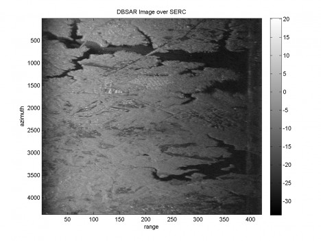
Yesterday we flew over two sites near Wallops, then we few over a spot in Maryland. That’s called the Smithsonian Environmental Research Center or SERC. There have been a lot of ground-truth measurements taken recently there, so it is a very good site for us. We used the DBSAR first thing and did a full data collection over SERC. The instrument worked really well, and the data collection was excellent. Then we flew lines for CAR to acquire its data. We’re very happy with the SERC flights.
After that, we flew to North Carolina and spent time flying over the Parker Tract. This site is part of NASA’s Carbon Monitoring System initiative, and scientists from that program have been out in the past few months making ground-truth measurements here. There is an excellent data set from the ground, and now our instruments have been able to get an excellent dataset from the air as well.
In North Carolina, we ran the SIMPL instrument first, and CAR also acquired data. When we ran the DBSAR, a few glitches showed back up again. We don’t like that, but we still can do good science out of North Carolina data sets.
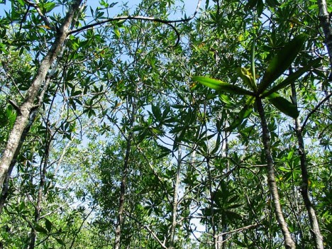
After those flights, we transited to Florida. We landed at Homestead Air force Base, and are staying nearby. The weather looks great for the morning flight – it should stay clear until at least noon-so we’re excited to get going here and run our instruments as long as we can today over our sites – mostly over the Everglades. This is a different ecosystem than our other sites. The vegetation is primarily mangrove forests.
The plan from here is to fly the Everglades today, using DBSAR mostly but also SIMPL and CAR. We’ll stay over in Florida one night, and fly our sites here again on Wednesday, then transit back to Wallops. That means we’ll still have Thursday and maybe Friday to do more work. We might head north again. We’d very much like to be able to fly the boulder field in Pennsylvania.
Why study rocks, when Eco 3D is primarily for vegetation? There are two reasons. First of all, flying over boulders helps us acquire data on non-vegetated areas, and this is helpful. Secondly, some of us are quite interested in planetary applications, especially for our radar. We want to be able to understand the geology of rocky surfaces, not just on Earth, but also surfaces that resemble those on Mars and Venus. Eventually we’d like to put radar on one of those planets, to help characterize and learn about the geology. Combining radar and lidar for geological purposes is very interesting.
When we go to the boulder field, we will be using polarimetric and interferometric techniques. This is completely experimental, and the first time we have measured boulder fields like this.
Oh, I should also fill you in a little about last week. I brought the computer home with me, to Maryland after our last flights. I put a monitor on it and worked much of the week to figure out our troubles. On Wednesday I went back to Wallops, and installed the DBSAR in a different location on the plane.
When we started to fly the first time, we had to install our computer on a new rack. That rack is very stiff and doesn’t dampen vibration at all – it actually can introduce additional vibration into the computer. Also, the rack was located right where the vibration is the highest – very close the propellers. What we did last week was to move the rack. We are now near the cockpit, in what they call “first class”. It’s a joke – there’s no first class section on this P3! But we are now in the front of the plane and the vibration is much less here. It’s really surprising – if you go stand where we used to be and then walk here, when the aircraft is running, you can feel a difference. We think this it is going to be very good for the DBSAR, to have less vibration.
It’s seemed to help so far. But still we have a small glitch. We lose small chunks of data every once in awhile. So despite the work this week, and despite moving the rack, there is still something we need to fix. And we are working on it. We will be doing a massive data collection over Florida today, so it will really test the instrument fully.
We’ve got to go now. The engines are spinning and they are saying it’s time to leave! I need to sign off. I’ll talk to you later and let you know how our Florida trip goes.
West River, Maryland 11:10 p.m.
This is Joanne Howl, the writer for this blog. Normally I take a back seat, not speaking myself but sharing the stories that the science team brings to me each day. Today I wanted to take a moment to speak as myself.
After a week layoff, the team is back in the air today. I haven’t heard from the field, yet and it’s pretty late. I think that means they’ve had a very long day. Work comes first – they have to complete their science objectives before taking the time to call and share their stories. I’m sure we’ll hear before long. Meanwhile, we have some catching up to do.
The past week has been a quiet one for the blog, because there were no flights. On Friday last week, Rafael and his crew returned from a very successful flight towards the north. They collected data from Howland, Maine, Bartlett Forest, New Hampshire and from sites in Quebec. Field experiments with instruments in development rarely go smoothly, and there were glitches and hiccups during the last week as expected. But, thanks to a lot of hard work and dedication, the teams gathered a good amount of excellent data and much is being learned about the instruments.
During the last flights, the DBSAR (radar) instrument had some glitches keeping up with the data load. It would drop data on occasion, although it still captured enough data to be very useful. But this glitch has been puzzling – and frustrating – for the team. The instrument performed perfectly in the lab and in the grounded aircraft. The problem only showed up in flight, and then not all the time. Intermittent problems are the hardest to solve, of course, especially when you need to be in the air to see the problem, and on the ground to fix it! They had worked hard on the problem, and DBSAR was performing better each flight as well as collecting good data.
The CAR instrument stopped working on the final day of last week’s trip as well. The CAR team was quite sure that it could be fixed completely and quickly – but they had to be on the ground to make the fix.
So when the science and engineering team landed on Friday, they headed home anticipating a full holiday weekend of work. They knew that they had instrument issues to tweak and data to analyze before they resumed flights on the Tuesday after Labor Day. They did work – very hard – and the instrument issues were nearly ironed out on Tuesday. The weather, however, wasn’t cooperative.
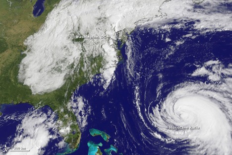
On September 1, Tropical Depression 13 formed in the Gulf of Mexico. As it strengthened and became Tropical Storm Lee, it was predicted to be a slow-moving rainmaker, but not too troublesome. As Lee made landfall on September 3, rain-filled convection bands stretched far northward. By September 5th, it was only a remnant of a Tropical Storm, but the clouds stretched along most of the eastern coast of the United States.
The remnants of Lee became merged with a stalled frontal system as Hurricane Katia was pushing north and west over the Atlantic Ocean, blocking Lee from escaping eastward and moving offshore. The winds from Lee and Katia pulled large amounts of moisture from the Gulf of Mexico and the Atlantic. The remnants of Lee dumped torrential rain as it plodded northward – weekly rainfall totals topped 10 inches across eight states. Elizabethtown, Pennsylvania recorded 15.37 inches for the week and the unofficial total at my home, south of Annapolis, Maryland, was 14 inches. The region had already been soaked by the rain from Hurricane Irene the week before, and the ground could not absorb the water. Rivers overflowed and in some areas, flooding was intense.
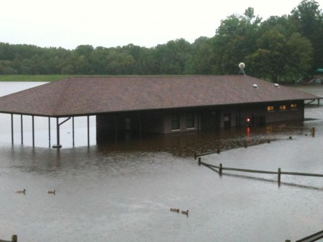
The clouds and dousing rain from the remnants of Lee effectively covered almost all of the target sites in New Hampshire, Maine, Pennsylvania, Maryland and North Carolina. CAR and SIMPL don’t do well with cloud cover – and the clouds were substantial all week long. Most of the areas also were substantially flooded. The instruments respond to wet foliage differently from dry foliage. In radar, you get more backscatter return from wet surfaces. That can be worked with, but it is an additional variable that must be analyzed. Standing floodwater creates another set of issues, because the water surface reflects radar waves differently from a wet surface, and very much differently than a dry surface. The science team could make adjustments for this, but flooded land creates variables and increases uncertainties.
In order to fly a science mission, one needs a sound and ready aircraft, working instruments and cooperative weather. By Tuesday, the aircraft was ready and the crew was willing. The CAR instrument was fixed and sound, and the DBSAR had been tuned up and was ready for another flight. But the weather – that difficult weather – was totally uncooperative. The decision was made to hold the flights until the weather was willing to cooperate.
Today the weather is clear and much of the flood waters have receded. The plan was to leave Wallops Island, Virginia very early, fly some sites in Maryland and North Carolina and then transit to Florida. The team planned an extremely long day with little rest. We’ll hear from the team shortly and share the story as we hear it.
