Bangor, ME 10:00 p.m.
From Rafael Rincon:
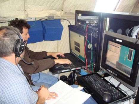
I’m pretty busy tonight, even though it’s already late. I’m in the hotel room after a long day, and I have had to bring the computer from the P3 to the room to do some trouble shooting tonight. I’ll be working very late again, it looks like, but that happens on these field campaigns a lot of the time.
We had a beautiful day for the flight, but unfortunately we had some trouble today. The DBSAR RAID is not keeping up with all the data that comes in. We know what is wrong, and I believe I can get it ready for tomorrow if I work on it tonight – and that’s what I’m doing now. We’ll be ready to go in the morning.
We were able to collect data from the DBSAR, but it kept me very, very busy trying to fix it when it would crash as it was collecting data. I think we have some good data, but how much the data was affected by the file problem, I’m not sure. I’ll know after I get a chance to look at some of the data, probably later tonight.
Basically the problem is that the RAID has too many files on the discs now. The more files on the disc, the longer it takes for a computer to write to it. The answer is to have less files, so I am transferring files from the RAID to an external hard drive – and then will delete the files so it can run well tomorrow. It’s hard work, and takes time, but it will get the instrument in shape again.
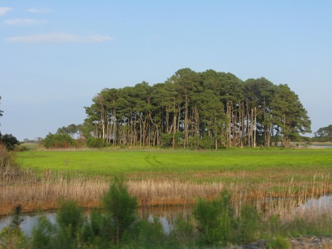
Today it was pretty decent weather for both SIMPL and for CAR. We were out early in the morning, and both SIMPL and CAR were able to gather great datasets over Howland. Their teams are really pleased with the data collected today.
Unfortunately at the very end of its last run, CAR developed a problem. Now the instrument is no longer responding. The good news is they did get a full day of data – it was good data, and they completed the science data they needed to collect over Howland. They think they know what is wrong, and it can be fixed, and that is good, too. The bad news is that they cannot fix it here, tonight. They need to go back to Wallops to fix it. So CAR is off line for the rest of our trip. But it will be ready for the southern flight campaign, which is supposed to start on Wednesday next week.
SIMPL had a better day, at least over Howland Forest. They gathered very good data over the sites we’ve measured in Howland and the instrument worked really well all day long. But SIMPL did have a problem of its own.
I think I told you yesterday that we needed to have authorization to turn the lidar on over Quebec. Well, when we left this morning, we had no authorization. We tried hard to get permission, but it never happened. We had it permission for last week, but someone had not thought to extend it for any additional time, in case we had trouble. Of course, we did have trouble. Now SIMPL has no trouble, and we have decent weather – but no permission. Without permission, we definitely would not turn the instrument on over Canada.
The radar was no trouble over Quebec. We had our permissions in place for that, so we flew the sites with the DBSAR. We collected plenty of data for DBSAR, although we were working to recover data each time the computer crashed. I think the data will be okay, but we just have to analyze it and see what was able to be captured. I certainly hustled all day long, and had no time to sight-see out the window today – there was too much going on with the RAID.
The sad thing was, late in the afternoon the SIMPL team heard that the authorization had been granted. But it was too late. We could not turn around and go back. It does open the door for tomorrow, though, and we hope to get back to Quebec and finish our work.
There is another site nearby which is very interesting, too. That is Bartlett Forest in New Hampshire. It’s an important site for us. It has been recently measured on the ground and with from the air with other instruments. We very much want to go there tomorrow, and we want to go back to Quebec tomorrow, too.
One challenge we have at Bartlett is that it is a military area, and there some restricted areas where we cannot fly. Some of those areas change every day, and we won’t know until the morning what areas will be open at what time.
We do know that we cannot fly high there, and that is difficult for the radar. We can make the lidar measurements with SIMPL easily, it likes being low. But the radar likes being high. With radar, the angle of incidence varies a whole lot when you are down low, from the near edge and the far edge of the image. The higher you can fly, the smaller the variation. From space, the variation is very, very small. But near the ground, you can get 40 or 50 degrees variation, depending on high you are flying. At Bartlett, we can’t fly over 2 km high because the airspace above is restricted. The lidar will do just fine at that altitude, so we will get good data from that, and we’ll squeeze the radar in at the highest altitude the pilot can give us.
So you see, it’s all very complicated. When the airspace will be open, what is restricted and what is not, and what the instrument likes for best data. It all has to be thought about and worked out, if we are to collect data.
It’s supposed to be a good day weather-wise. New Hampshire looks great in the morning. Quebec may have some scattered showers, but we should be able to get there when there is not much rain, at least we hope we can work it out that way. SIMPL has permission now, and we want that data. We also really do want to redo the DBSAR data as necessary, since we had some trouble. We’d also like to implement 2 interferometric passes offset by 60 meters with the DBSAR. We’ll do two of those measurements over the sites, then that is it. The two passes for DBSAR alone will take about an hour.
Our plan for tomorrow is to get up early and check to see when we can fly what areas in New Hampshire, and check on the weather in Quebec. We’ll then figure out which one we’ll fly first. After flying New Hampshire and Quebec, we transit to Wallops, arriving there late afternoon. And that will finish this leg of the field campaign.
Next week we’ll be flying south. We hope to fly over sites in Florida Wednesday morning and collect data from all three instruments. We are also discussing the possibility of leaving Wallops on Tuesday mid-day, and flying straight to Florida, making no measurements. This would get us there so we can start collecting data first thing in the morning. The weather is a lot better in the morning in Florida – the afternoons usually cloud up and have rain.
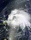
And speaking of weather – there’s another storm out in the Atlantic Ocean. We looked at this new storm – Katia – and it’s not supposed to hit Florida. If we have weather from the storm, well, we’ll take care of it. We do have some extra time built into our schedule, a contingency week, so if the storm begins to head towards where we are working, we have the ability to postpone the flight. Now, if we have more storms after that, then we are done. We don’t have use of the aircraft forever. September 16 is our last day. After that the aircraft has to get ready for the new mission.
Bangor, Maine 10:00 p.m. EDT
I’m Rafael Rincon, the principal investigator for DB-SAR, and I’m glad to tell you that things went very smoothly today. It was a good start to what should be a great week in the field.
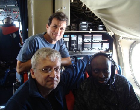
I flew on the P3 last week and will be working this set of flights, too. I’ll be the one telling you about our work this week. Each day I’ll get up very early, spend the day in the air working the DBSAR, and once we are on the ground I analyze some data and help plan flights for the next day. After that is all done, I call our team writer, Joanne Howl, and give her the details of the day so she can get it written down and posted in the blog.
As you know, we had some challenges on our first week of flights. There were instrument problems, an earthquake, and a hurricane. The, once we began a really data collection run, we were cut off and had to land right away because of bad weather. Finally, they called the P3 home a day early, to protect it from what looked like it would be a direct hit from Hurricane Irene.
All I can say is this is the challenge of science in the field. You can expect the unexpected – it happens. And you just move ahead and work around it.
We’re set to have a great week. The aircraft is back home from West Virginia, where it was sheltered from Hurricane Irene. Our facility at Wallops is sound – no hurricane damage to be seen, and it is running well. The weather forecast for the next several days where we want to fly – Maine, Quebec and New Hampshire – is wonderful, with low winds and lots of sunshine. And our instruments are working fine. We have everything we need for a good trip.
What are the chances something will go wrong? Just as good as always! Just because we have a lot of challenges behind us, it doesn’t mean that there are no challenges ahead! It’s science, and we’re in the field. Things happen. We’ll take what comes and we’ll do our work, and we will overcome any problem that comes up.
This morning, there were no problems at all. We got up very early, and took off from Wallops at 9:00 a.m., just as planned. Flying north to Maine, we looked for evidence of hurricane damage, but we were flying so high we couldn’t see if trees were down on the ground – just too high for details. But there was one amazing thing that we could see.
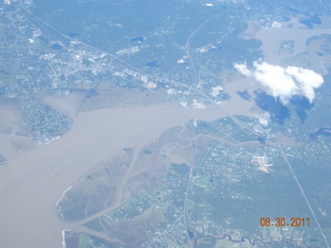
When we were in transit from Wallops to Maine, at one point where the Hudson River comes into the ocean, we could see that the Hudson was very muddy from all the sediment washed into it from all the rain in Irene. And there was a big layer of mud that separated the coastline from the ocean water. It was thick mud, and it was huge – all along the shoreline, through the river and out into the ocean. It was very thick and we could see it very clearly. It was a very impressive sight.
When we arrived in Maine, we had some broken clouds, and this wasn’t the best for SIMPL or CAR. Those instruments can measure clouds, but for this mission we want them to look at canopy height of the forest. So if you get a cloud between the forest and those instruments, it reflects back to the aircraft, interfering with canopy measurements.
There were some areas of open sky, with no or few clouds, so Dave Harding, with SIMPL, decided to do his measurements first. We were flying low, at about 1200 meters (1.2 meters), which is the altitude that this instrument likes. We got a pretty good radar set for this lidar instrument, and breaks in the cloud let us get measurements of forest height with it.
After SIMPLE completed its measurements, it was the time for CAR to have its allocated turn. CAR is even more sensitive to clouds, so the PI, Charles Gatebe, decided not to use the time making those measurements now, but to wait for clearer skies tomorrow or Thursday to make those measurements.
After that, we went to a high altitude-about 5,500 meters (5.5 km) and I resumed the DBSAR measurements right where they were cut off last Thursday, when we were asked to land immediately due to weather.
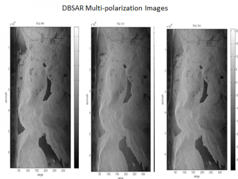
We operate the radar in a couple of different modes. First we have a side looking synthetic aperture radar mode. The other is a wide beam mode. In wide beam we capture a full field of view under the aircraft. From there, we can synthesize as many beams as we want on either side of the aircraft. Each beam is basically a field of view of different spots on the ground, and we can look at specific spots because of the beam forming technique. So with wide beam we illuminate a wide view and by synthesizing the beam, we can look at a more narrow field.
This is a new technique and we tested before, and it worked well. This time we have added a test with a fully polarimetric measurement. We are doing that test for the first time ever, starting with this trip. And I can see that, so far, we are getting very good results.

How do I know the results are so good, already, since the data doesn’t get fully analyzed until we get back to the lab? I have two ways to tell. First, when we are collecting the data, I am watching the raw signal on my laptop. I see the display in real time, and I can see the shape and the extent of the signal as it comes in. This gives me a real good idea if the data is good or not.
Also, after the flight is over, then I download the data into my laptop and can generate a quick view for a few samples, so I can make sure the radar operated right away. For instance today I just processed a file we generated during the data collection today. It takes about a half-hour to process a quick look – I did that, and it looks very good. Each file holds about a gigabyte of data, and that’s for about 30 seconds of actual data collection. This quick processing will give us an image of an area of about 6 km in length and 4 km in width.
Just to make sure everything is working fine for the next flight. I pretty much do this each night.
I wanted to mention, also that we do collect data from the same area with each instrument, but we don’t usually operate them at the same time. We could do that if we wanted to do so, but ideal data collection conditions for DBSAR and SIMPL are different. The radar (DBSAR) likes to fly high – at about 5.5 kilometers. It is imaging a large surface area, so it needs to be up high to gather the data. The Lidar likes to fly low, at around 1.2 kilometers. It is low powered so if you go up too high, you can’t get the return form the ground.
There is an experimental mode in which we operate the radar as an altimeter, so we look at a single line straight on and can get the height of the forest. I have collected data with the radar and the lidar simultaneously in that mode. In that way, we can compare the two side by side, and it gives us additional information.
The weather tomorrow looks very good – winds are low with very little cloud cover expected. As soon as we take off, we’ll have SIMPL and CAR finish their measurements in Maine, and then we will head for Quebec, one of the other main sites for this campaign. It’s important, because the forest ecosystem type is different here. We are looking at a northern hardwood transitional forest here, with some boreal forest features, but the site in Quebec is a boreal forest. It’s important for us to get data from diverse ecosystems, so Quebec is important.
The one issue have right now is permission to turn on the lidar in Quebec. When you fly over a country’s sovereign territory, you can’t just go turn on instruments and fly around. You need government permissions to fly, and also permission to run each instrument. We requested, and had received, permission to turn the lidar on at our sites for last week. But it was over last week, and this week we do not have permission to work yet this week. We are waiting for an extension of the original permit, or a new one, and hope we get it by tomorrow’s flight. The radar (the DBSAR) has all authorizations granted, so we can fly the radar for sure. So we will fly, no matter what. It’s just a question of if we can gather data from SIMPL or not tomorrow. We hope we can!
Bangor, ME 6 p.m. EDT
From Jon Ranson:
We had a great day and gathered fantastic data. It felt so good to be working and getting the data – finally. Unfortunately, our flight only lasted three hours. Then the Mission Manager, Martin Nowicki, came out of the cabin with a serious look on his face. He gave us bad news: there was bad weather threatening, and we had no choice but to cease collecting data immediately and return to the Bangor airport. What a disappointment to be reined in by bad weather!
Well, field work is always risky, and science flights are always at high risk of running into problems. You need three things to do remote sensing from the air: a stable aircraft, functioning instruments, and good weather. The aircraft has been perfect from the beginning. The instruments are finally humming along perfectly. But now we don’t have the weather. Sometimes it’s just hard to get all three things working together. All you can do is your best, and persist despite difficulties.
And we’ve done that. I’m very gratified that we were able to get three hours of flying in today – it was excellent for the DBSAR, which can acquire accurate data even through dense clouds, like today’s conditions. We were able to fly many of the most critical lines and we were able to look at some of the data later in the day, and it looks just great.
So now we do know that the DBSAR works over the primary forests we wanted to look at on this part of the mission. We really wanted additional data, but what we were able to collect is very strong and I’m satisfied that it will be very valuable for our work.
Today’s emphasis was on the DBSAR, but we’d hoped to be able to run CAR and SIMPL as well. Unfortunately, there was enough cloud cover that they couldn’t gather much data over forests, but they did get to do measurements over cloud. Both instruments are used in other research for cloud cover, so they were able to take advantage of the situation to work on cloud reflectance. Not our current mission, but it’s better to gather some information than sit there unable to do anything useful.
With the DBSAR, were wanted to get data in multiple polarizations, so we made a run north to south and then a run south to north swaths over the same area. We then fly another set of lines in the same direction, to get additional looks at the same area to use for interferometry, which helps us understand the three dimensional structure of the forest. Then we cover the plot in a wide swath mode, taking measurements across a wide area that reaches out from both sides of the plane. We are experimenting with single pass interferometry in this mode, too.
Under ideal conditions, SIMPL would measure the forest height and vertical structure of the forest. The vertical structure is the way the branches and leaves are structured. Knowing the structure can help us understand how the canopy is put together, so it can help us understand forest type, stand density and biomass better. Our DBSAR will give us a broad swath of data, while SIMPL will take more limited spot samples of our swath area, but they should work together well.
The CAR will be used to assess the bidirectional reflectance of the forest canopy. Those measurements are related to the amount of leaf area in a canopy, whether the leaves are structured in clumps or are more uniformly distributed throughout, and also helps assess what type of forest we are looking at. So it’s a helpful addition to the DBSAR and SIMPL data.
Despite the bad weather, the only problem I experienced was the inability to collect ground data with CAR and SIMPL. It was a cloudy day, but we didn’t see any rain until after we landed at the airport. We did get a thunderstorm then, but it didn’t seem like anything particularly severe to me. Inside the plane, we felt no turbulence to speak of, and the ride was smooth most of the day. That P3 is really a great plane, and the crew is top notch, so it’s no surprise we had a good flight, despite weather.
After we landed, I called Guoqing at Howland Forest to see how he was doing and what the weather was like there. He reported that the forest didn’t have any rain until the afternoon. That’s great news, and meant that we were taking our measurements in fair weather in the field, and they were able to measure at the same, time, too. That’s kind of nice to think that our colleagues were taking measurements in the forest as we flew overhead.
It was disappointing for the flight to be scrubbed this morning, but the weather news is even worse than that. Hurricane Irene is now predicted to come up the Delmarva peninsula, and the threat to Wallops is real. The experts at Wallops have decided that the P3 would not be safe weathering a direct hit of a Category 3 storm, which appears to be a possibility at this point. So they have called the plane home. They want to send it to a safe site in West Virginia before the end of the day tomorrow. So we go home in the morning.
The weather in Bangor is supposed to be beautiful tomorrow, with no rain and plenty of sun in the forecast. Now we’ve finally got the weather we need for a great day of data gathering. And our instruments are running perfectly. But now the third piece is missing – we don’t have an aircraft.
So, thanks to Irene’s approach, we head home tomorrow. We’ll be at Wallops by 10 a.m., and then I’ll join the coastal evacuation traffic heading west. All I can hope is that the Bay Bridge – a terrific traffic bottleneck for ordinary summer weekend beach traffic – isn’t jam-packed with evacuation traffic.
The Howland crew plans to work in the field all day tomorrow, then they try to get back to Maryland in time to make a few storm preparations. Most likely, they will drive all night long, from Maine to Greenbelt, swapping drivers to make the best time.
Despite our difficulties, the mission has really only just begun. We’ve got the Eco-3D South Flight to fly shortly, as well as flights over sites in Maryland. We’ve only just begun the blog, too – we’ll continue soon. Stay tuned!
Wallops Island, Virginia 6:00 p.m. EDT
From Jon Ranson:
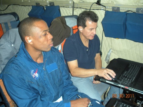
I’m back at Wallop’s this evening after a quick trip back home. Last evening we made the decision to not fly today, so the DBSAR RAID could be fixed. I’m not an engineer, and couldn’t offer much to the RAID-fixing effort, so I had a little free time on my hands.
The news from here is great. It looks like the instrument is fixed and should be ready to roll in the morning. We’re planning to leave early in the morning, do a quick check-out, give a few high-fives for a healthy instrument, and then head to Maine. We should get two full days of data collection before we have to turn home on Friday evening. It’s less time than we’d planned, but it will be good time, and I’ll happily take it.
Yesterday I was under the impression that the parts had to be special ordered and would arrive early in this morning. It turns out that our engineers were more resourceful than that. They took an evening ride out to Salisbury, went shopping at Best Buy, and bought what they needed to get the job done. They got up very early yesterday morning and worked all day long on this. When I arrived around five o’clock this evening, they were still hard at work. So now, thanks to the long hours, resourcefulness and great skill, Rafael and Martin got it fixed. The DBSAR RAID looks very stable, and we expect it to work very reliably in the air.
The SIMPL team took the opportunity to tweak their instrument, too. Phil Dabney discovered that the SIMPL system was using almost all the capability of their UPS (uninterruptible power source). The instrument performed fine with the UPS, but there was very little reserve to deal with extra power needs. So the team managed to find a replacement with greater capability, and they are happier with their stability now.
Tomorrow’s plan is to get up very early, eat a breakfast and grab a “picnic” lunch at the local deli, and meet at the hangar at 6 AM. The flight crew will give us a fly/no fly decision, based on the weather situation at that time. Because that pesky hurricane is still creeping closer, there’s a bit of doubt that we’ll go, but I tell you right now, we’re all totally dedicated to getting this mission accomplished if there is a safe way to do so.
Once we lift off, around 8 a.m., we’ll fly to the Maine sites, and work hard acquiring data from all three instruments for at least 6 hours, maybe more. We’ll stay overnight near the Bangor airport, then get up early and fly another full day.
Our original flight plan called for at least four days of flight. We wanted to collect data at Howland Forest and other sites in Maine, Bartlett Forest in New Hampshire, a boulder field in Pennsylvania, and some sites in Quebec. These sites were carefully chosen to give us access to a wide range of forest types as well as a site with no forest at all (the boulder field). It’s really important to see how these instruments perform with various vegetation sites.
We also selected sites that have had recent measurements made in the field, so we can compare to recent ground truth. Many of the sites have been measured this year for the Carbon Monitoring System’s Biomass Pilot program, so we’ll be able to compare our biomass measurements against their measurements. The Carbon Monitoring System is a NASA initiative in which researchers in biomass and flux (atmospheric carbon) will create data products of carbon in terrestrial vegetation and in the atmosphere, and these products will be of known accuracy as well as be useful to end-users, such as researchers, forest managers, and policy makers.
When measuring forests, we have long considered that on-the-ground, first hand measurements are the gold standard for accuracy. When we work to improve remote-sensing instruments, it’s important to compare to this gold standard, and that’s what we are trying to do by collecting data over sites with recent ground-truth measurements collected. Using the CMS sites has the additional benefit of providing data to that program which we hope can enhance their data regarding the biomass of the area. We hope that the Eco-3D can prove very valuable to programs. like NASA’s CMS, which are designed to enhance our understanding of forest biomass well as provide data of known accuracies that can prove useful to fill a variety of needs.
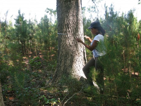
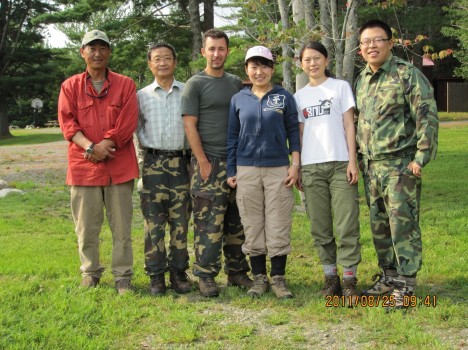
One of the primary places we are interested in measuring tomorrow is Howland Forest. Portions of this forest were measured in 2009, 2010, and the CMS pilot measured some parts of it earlier this year. We have sent a crew to measure this week as well, in conjunction with our flights, so we can have ground truth that is nearly simultaneous with our instrument collections. That crew is led by Guoqing Sun, a scientist from Goddard. The crew members are living in cabins near the forest, and have been out every day gathering ground-truth data for us.
Another scientist, Miguel Roman, is driving a car through the areas we plan to measure with Eco-3D. He is surveying the sites visually to gather impressions we can compare with the flight data, and is also taking measurements of aerosol thickness with handheld sun photometers. This helps the program in various ways – since our instruments are gathering information through the atmosphere, it is helpful to quantify that variable.
The entire campaign is designed to have a week-long set of flights to the north, a week-long set of flights to the south and some local flights in Maryland over sites where the forests have been extensively measured by NASA very recently, both for the Carbon Monitoring System and other NASA research programs. In conjunction with that, we have field crews out taking various measurements. The goal is to gather as much data as possible, in as many ways as possible from specific sites. The sites are chosen to give us as many types of forest as possible – from the boreal forests in Maine to the Mangrove forests in Florida.
Despite being forced to compress a week’s measurements into two long days, we’ll still have plenty of time and flight hours to gather excellent data and produce a good result. Weather permitting, we’ll be in the air and gathering that data early tomorrow morning.
Wallops Island, Virginia 5:30 p.m.
From Jon Ranson:
This morning started out just perfect for collecting data from the air. It was a beautiful sunny day with good weather, and we did our best to take advantage of it. We were up in the air early and take-off went well, without a hitch. The check-out flight for DBSAR wasn’t quite so good.
We’d hoped that the instrument check out portion of the flight would prove our DBSAR to be sound, but that didn’t happen – the intermittent problem showed back up. We had to land at Wallops again, and hoped we could fix it quickly. But no quick fix was available. Our engineers will need to order a part and then do a major fix of the DBSAR. Or more specifically, the RAID for the DBSAR.

RAID stands for “Redundant Array of Independent Disks”. It is basically connects five discs together, and distributes the collected data across those discs, so we can collect high volumes of data very quickly. The RAID has experience two problems. First, the discs don’t sync up correctly with the computer. The second is that is they sometimes don’t record at a fast rate. Sometimes they only record at 30% of expected speed, so this really limits the data that they can acquire. So we can’t use the instrument like it is, we really have to fix it before we make our science flights.
Last night we planned on making to Maine today and making measurements, but the nagging problem with the RAID meant we had to do a thorough check out and see if we could get it fixed. We did the checkout, and it is clear there’s no immediate fix available.
After studying weather and timelines, we’ve decided that we have one day to fix the RAID. If it can be fixed tomorrow, we’ll fly Thursday and Friday. If the instrument is still being stubborn on Thursday morning, we’ll likely have to scrub the entire set of flights this week, and I’m not sure what that will mean. We need to find a way to collect our data, somehow.
The good news is that while we were checking out the radar we also flew 3 lines over measured forest plots at Wallops. The SIMPL instrument appeared to be working fine, and the CAR instrument also acquired good data. So all we have to do is get the DBSAR fixed, and we’re golden.
We also had a little excitement of a different type this afternoon. Well, it was very little excitement here, really, although our friends and loved ones at home sure had stories to tell. We were sitting in our meeting when a 5.9 earthquake struck our region! Personally, I didn’t feel a thing, but someone else did mentioned feel something odd. Pretty soon, though, we had people checking in to see if we were okay, so we found out about the earthquake pretty quickly. I guess there is something about the soil at Wallops, or between Wallops and the epicenter in Virginia, that prevented most of the tremors from shaking us up.
And if earthquakes and stubborn instruments aren’t enough, there’s this giant hurricane threatening the east coast. It’s in the Bahamas now, and our weather is beautiful, but it is tracking towards us and predictions are unclear how soon it may arrive. If it speeds up, it may impact our return flight home. None of us want to be cut off from home as Irene works her magic here, then comes calling in Maine. So any decision we make will take the storm forecasts into close account.
You know, this is a pretty good illustration of what science in the field can be like. Sometimes it sounds fairly glamorous to be a scientist and travel around and do cool things – at least that’s what I’ve been told. And yes, field work can be fun, no doubt about it. But a field campaign really is work and like any other work, it can be both difficult and frustrating. The malfunctioning instrument is just part of the picture. Such stuff happens, and we’ll get it fixed and move on. The earthquake and hurricane? Well, they are just a little bonus excitement. I’m betting we’ll get at least some good data before this section of the campaign ends, despite all the challenge.
So our plan is to give Rafael Rincon, the DBSAR Principal Investigator and Martin Perrine, the DBSAR Instrument Engineer, a full day to fix the RAID. If they can get it fixed and tested on the ground by the end of the day tomorrow, then we’ll fly early Thursday morning. We’ll then fly up to Maine, and do an extended day of measurements over Maine and New Hampshire, but we’ll have to delete the site we’d hope to fly in Canada. We’ll also fly Friday, and hope to return to Wallops Friday night. If necessary, we can come home on Saturday. At this point, our next move depends on the RAID. Oh, and I guess Hurricane Irene gets a vote, too.
I do want to say that everyone here is working really hard. Everyone is cooperating and in a good mood despite the troubles. The flight crew, too, is very helpful to our team and they, along with everyone, are working hard to make this mission succeed. Flights are risky business, and they don’t always go as planned. In the end, we’re going to get our data, I am just sure of it. Meanwhile, we’ll work hard and enjoy our work as much as we can.
