

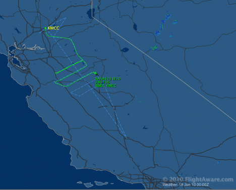
Just a brief heads-up, to signal a couple of particularly interesting links. You can check the status of the mission at any time by pointing your browser at this public Wiki page, and make sure we deliver our promises of “flying around” all over California by following the B-200 trajectories on Flight Aware. Just enter NASA529 as a tail number in the “Private Flight Tracker” field.
You can practice on today’s flight, which is took off a few minutes ago for an important coordinated mission with a third and fourth aircraft (the second being the G-1): the NOAA P3 and the NOAA Twin Otter. Below you see what you should if you followed the instructions correctly.
Last but not least, how to forget Rahul Zaveri’s memorable entries?

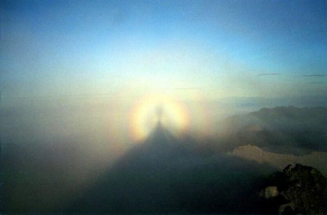
Why is our satellite mission named “Glory”? I can give you an explanation based on this short movie, which I captured from a downward looking camera on the B-200 during a recent flight.
While descending for landing, we encountered a cloud deck, and I received a clue for what, in geek terms, we call a scattering angle of 180 degrees, or backscattering direction (in this case, the scattering angle is the “Sun – point on cloud – me” angle).
In other words, I noticed the aircraft shadow on the clouds.
[youtube ddd5CUizyto 468]
A glory captured by the NASA B-200 downward looking camera on June
5th, 2010.
Sun beams entering a cloud droplet are internally reflected, sort of like balls in a circular pool table. Some of them exit the droplet after one of these reflections, to form the regular rainbow (or “cloudbow” in this case, barely visible on the left of the frames).
Others take a few more bounces. Those that exit the droplet in the same direction they came from form a small circular rainbow called a Glory, whose features are enhanced when observed in polarized light. The prism “color-splitting” effect, as for the primary rainbow, is due to the slightly different deflection angles that different colors take when crossing the interface between air and water (or, for all that matters, between any two media with different refractive indices).
It is good practice to always search for the Glory. An ideal chance occurs when you fly over clouds, but remember that only your ability to see the airplane shadow will tell you if you chose the right seat. In proximity of the shadow, the alignment between you and the Sun is appropriate to make sure that the Sun beams are returned to you straight back by the cloud droplets.
For those scared who are scared to fly, yet are avid hikers, pay attention if you find yourself between the Sun and a fog or cloud bank. The multicolor crown developing around the shadow of your head can make you a saint, and gave name to this glorious optical phenomenon. Hallelujah!
As previously stated, it is Cool like in Cool, CA.
Our first science meeting took place midway between T0 (McClellan Air Force Base) and T1 (Cool), so I couldn’t get a better chance to drive to the site that marks our downwind sampling location (T1, that is).
Off Rt. 80, you’ve got to follow the bends of 49 and down the gorge past Auburn, a real pretty town draped around the turns of historic Rt. 40. Then you drive up for another 4 miles past the Cool quarry.

Amidst this rural, very rural area, lies Northside Elementary school. Classes have been over for a week now, yet the backyard still hosts activity spurred by eternal kids with grey hair.
[youtube EX5qIuVhGWs 468]
This very repetitive bird emanates sound waves and the wind and
temperature in the atmosphere above are derived from their influence
on the speed of sound.
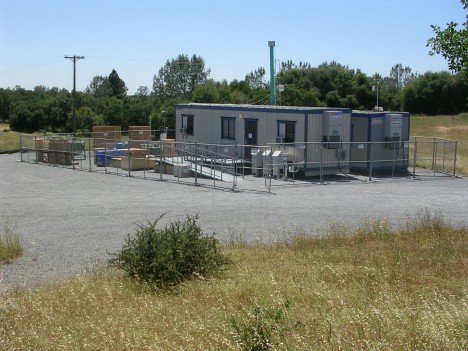
In trailers parked as control stations for ground instrumentation they are monitoring every spike in incoming particulates. Everything is very peaceful…trees, Sun, and even digital birds chirping.

Rushing back to the meeting, I found a room plenty with people anxious to display their first week of data. It is very important in the beginning of a campaign to make sure we establish a consistent baseline among all the different instruments.
Big discussions have already been engaged as to what pertains to local events as opposed to consistent transport patterns, but some points confirm the expectations. On a daily basis, a wide variety of small particles including black carbon get transported until they’re detected miles downwind from the sources, growing in size and getting coated with sulfates and other organics. More mysteries are hidden behind the unexpected amount of ultrafine particles, less than 10 nanometers in size (1 nanometer is a billionth of a meter). We’re not sure where they come from but they’re all around the urban areas.
Matteo
On June 15, the U.S. Coast Guard Cutter Healy (photo above) will depart Dutch Harbor, Alaska, for its 5-week-long journey north through the Bering Strait to the Chukchi and Beaufort Seas. Along the way, forty-three NASA-funded scientists will study how climate change is affecting the ecology of the Arctic. They will collect samples and even disembark for extended periods to work directly on the sea ice. They’ll study everything from the Arctic Ocean’s optical properties (how it reflects and absorbs light) to phytoplankton physiology.
To follow the expedition in coming weeks, please visit NASA’s ICESCAPE blog.
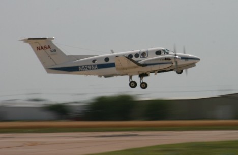
There’re two instruments on the Beech King Air B200. One is the HSRL, which stands for High Spectral Resolution LIDAR. The latter word is an acronym born out of the marriage between RADAR and LASER. Even Radiohead use it. The one mounted on the B200 is an advanced device that my colleagues at NASA Langley have been extensively deploying. It pulses a laser beam straight downwards, and records the time it takes for light to come straight back after it bounces off particles. Based on this information, the atmosphere below the airplane is profiled and the height of aerosols layers effectively located.

The Research Scanning Polarimeter (RSP) is somewhat weirder, as polarization is a kind of information that is greatly masked to humans’ vision capabilities. Ask bees. If you wear sunglasses though, you should know that they cut the glare because they filter out light waves oscillating in all directions other than that vibrating in a certain direction.
Light is a wave, but most instruments can only measure the amplitude (=intensity) of it. Instead, the RSP adds to it by recording at which angle the light wave vibrates. As you can expect, the change of this angle as a light wave scatters off a a particle is extremely sensitive to the size and shape of the particle.
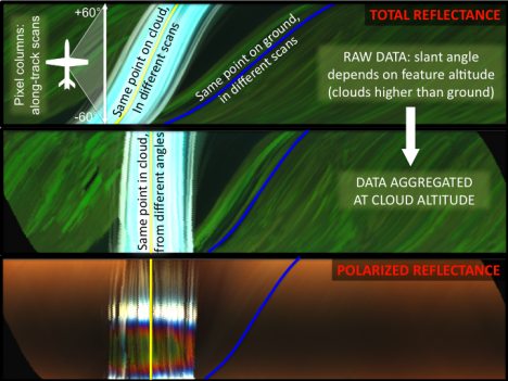
We hope we can exploit the synergy between these two instruments to nail the vertical distribution and nature of aerosols in the atmosphere. Our studies confirm the potential of integrating the information derived by the complementary capabilities of the two instruments, sort of “Tell me where you are, and I’ll tell you who you are”.
Why do we do this? These instruments are “the little brothers” of the CALIPSO LIDAR (already in space), and the polarimeter that will be launched onboard the Glory mission at the end of this year. These satellites will fly shoulder by shoulder (just a few seconds apart!), therefore observing at any instant the same scene. You can even have your name orbiting with us!
-Matteo