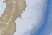
This map shows the location of a large aftershock off the coast of Japan on April 7, 2011.
Published Apr 7, 2011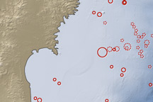
On March 11, 2011, a magnitude 8.9 earthquake struck off the east coast of Honshu, Japan, about 130 kilometers (80 miles) east of Sendai. If the initial estimate is confirmed, it will be the fifth largest earthquake in recorded history.
Published Mar 12, 2011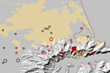
This map shows the location of earthquakes on near Christchurch, New Zealand between September 3, 2010, and February 22, 2011.
Published Feb 23, 2011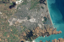
This natural color image of Christchurch, New Zealand, is overlain with a measure of the ground shaking in the area during the February 2011 earthquake.
Published Mar 9, 2011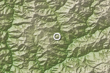
A deadly magnitude 6.1 earthquake struck Bhutan on September 21, 2009.
Published Sep 21, 2009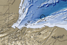
This image shows the topography and bathymetry of the region surrounding the earthquakes that occurred on May 28-29, 2009. Red circles indicate quake locations, and fine black lines indicate fault lines.
Published May 30, 2009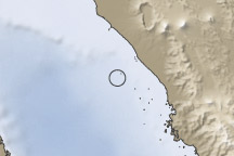
This image shows the topography and bathymetry near Sumatra, Indonesia, where hundreds or thousands of people were feared dead in the wake of a magnitude 7.6 earthquake that struck on September 30, 2009.
Published Sep 30, 2009
This image shows the topography, bathymetry, fault lines, and earthquake locations related to the earthquake that struck off the coast of Indonesia on October 25, 2010.
Published Oct 27, 2010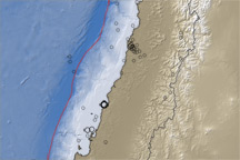
This map of topography and water depth along the Chilean coast includes black circles that indicate aftershocks with a magnitude of 5.0 or larger that occurred between March 5 and 12, 2010, following the large earthquake on February 27.
Published Mar 11, 2010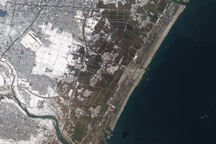
Acquired March 18, 2011, this natural-color image shows agricultural fields near Sendai, Japan, covered with either snow or flood water.
Published Mar 20, 2011