Acquired September 21, 2011, and September 22, 2009, these false-color images compare conditions in southern Pakistan, which suffered severe flooding in 2011.
Published Sep 21, 2011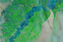
Acquired August 8,10, and 12, 2010, these false-color images show a substantial rise in water levels on the Indus River downstream from Sukkur, Pakistan.
Published Aug 12, 2010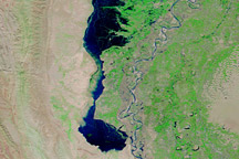
Images from September 3, October 2, and November 1, 2010, show the development and slow draining of a massive floodwater lake west of the Indus River.
Published Nov 3, 2010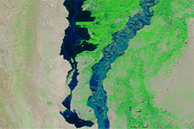
Acquired July 19, August 11, and September 7, 2010, these false-color images span a 50-day period in which the Indus River spawned a parallel river to the west.
Published Sep 7, 2010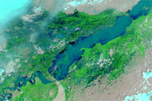
Acquired on August 8, 2010, and July 18, 2010, these false-color images show a dramatic difference in water levels along the southern extent of the Indus River, midway through Pakistan’s monsoon season.
Published Aug 8, 2010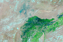
Acquired on July 30, 2010 (top), and June 5, 2010 (bottom), these images show flooding along the Indus River in Pakistan.
Published Jul 30, 2010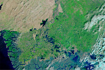
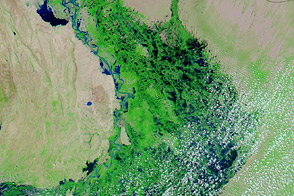
These false-color images show parts of Pakistan affected by the 2010 monsoon floods. The image from November 201, shows the area after flooding. The image from November 2009 shows conditions one year before.
Published Nov 15, 2010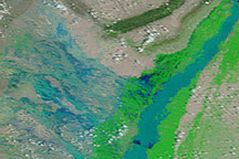
In August 2010, entire villages were washed away, more than 1,100 people died, and an estimated 2.5 million people were affected by dramatic monsoon rains.
Published Aug 3, 2010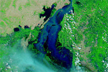
Acquired September 2, 2010, and July 16, 2010, these false-color images show an area along the Pakistan coast before and after floodwaters submerged the town of Sujawal.
Published Sep 2, 2010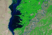
Accessed October 11, 2009, August 11, 2010, and October 12, 2010, these false-color images show lingering effects of the 2010 monsoon season in Pakistan.
Published Oct 12, 2010