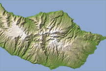
This topographic map of the Portuguese Island of Madeira helps illustrate why population centers on the island are prone to flooding.
Published Feb 24, 2010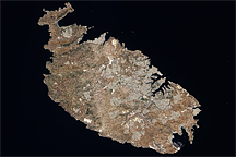
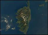
Acquired August 12, 2009, this true-color image shows the Mediterranean island of Malta, the largest island in the Republic of Malta archipelago.
Published Dec 13, 2009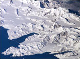
There is no permanent human base on South Georgia Island, a British territory in the South Atlantic Ocean that lies 1,300 kilometers east of the Falkland Islands. The crew of the International Space Station captured this image of the rugged and isolated landscape of the northern shore of the island. The first recorded explorer to land on the island was Captain James Cook aboard the HMS Resolution in 1775. He mapped part of the coastline, but was discouraged by the thick ice cover, lack of vegetation, and steep mountains. Mt. Paget, the highest peak, rises to 2,934 meters (9,625 feet) above sea level, and the island supports 161 glaciers. Cook named the southernmost point of the island “Cape Disappointment” when he realized he had not reached Antarctica.
Published Oct 17, 2005
The most interesting geology lies just offshore and below the water line of this Northwest Australian island.
Published Aug 3, 2015

This natural-color image shows Henrietta Island, with a smooth, dome-capped surface and a rugged coastline, illuminated by low-angled sunlight.
Published May 3, 2009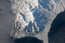
This astronaut photograph shows the southern end of Paramushir Island after a snowfall. Four volcanic centers are brightly lit on their western slopes and deeply shadowed to the east.
Published Jul 12, 2010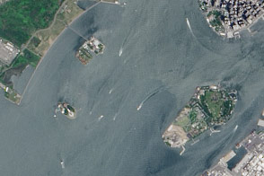
A pair of modest oyster flats turned into two of most important islands in the United States.
Published Mar 20, 2016