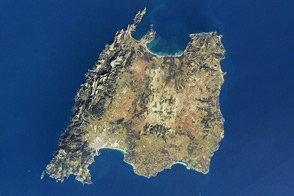
With mountains and coastline in close proximity, the island is a popular holiday destination for Europeans.
Published Feb 6, 2012

The most interesting geology lies just offshore and below the water line of this Northwest Australian island.
Published Aug 3, 2015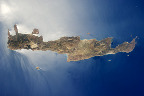
Crete is the largest and most heavily populated island of Greece.
Published Aug 15, 2011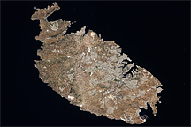
Acquired August 12, 2009, this true-color image shows the Mediterranean island of Malta, the largest island in the Republic of Malta archipelago.
Published Dec 13, 2009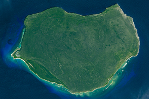
The small Puerto Rican island is a natural reserve that has been nicknamed the “Galapagos of the Caribbean.”
Published Feb 28, 2016
The ghostly white shapes northeast and immediately southwest of Wrangel Island are sea ice. Over the course of the satellite record, Arctic sea ice has advanced and retreated past Wrangel Island many times. From 1979 to 2000, the sea ice edge at the end of summer generally fell somewhere in the vicinity of Wrangel Island, but this is not the first summer when the sea ice edge has retreated well north of the island.
Published Aug 29, 2008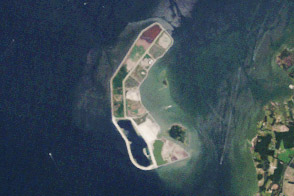
Poplar Island is rising back out of the Chesapeake...with a little help.
Published Jun 30, 2012
Named Isla de Aves in Spanish, (meaning “Island of the Birds”) Aves Island lies west of the Lesser Antilles in the Caribbean. It provides a nesting site to green sea turtles (Chelonia mydas) and, of course, birds. Because the abundant bird droppings, known as guano, could be used in fertilizer and gunpowder, guano miners worked on the island until they depleted the supply. Since its discovery by Europeans, likely in the late 16th century, Aves Island was subsequently claimed by several European nations. The island is currently claimed by Venezuela, although disputes about ownership of the island, and the surrounding exclusive economic zone in the Caribbean, continue today.
Published Jun 19, 2006
This photo-like image of Chincoteague Island and the southern section of Assateague was acquired by the IKONOS satellite on June 27, 2001.
Published Oct 28, 2008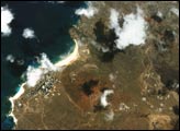
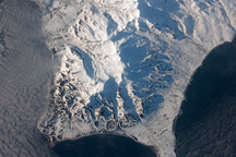
This astronaut photograph shows the southern end of Paramushir Island after a snowfall. Four volcanic centers are brightly lit on their western slopes and deeply shadowed to the east.
Published Jul 12, 2010alert message
