Acquired June 11,2010, this natural-color image shows apparent steam filling the caldera of Sarychev Peak.
Published Jun 11, 2010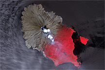
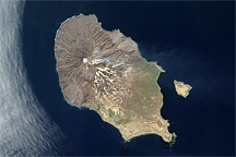
A pair of before-and-after images shows how the June 2009 eruption of Sarychev Peak Volcano transformed Matua Island.
Published Jul 5, 2009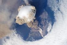
A fortuitous orbit of the International Space Station in 2009 offered the astronauts a striking view of the volcano in an early stage of eruption.
Published Jun 22, 2009
On June 18, 2009, Sarychev Peak produced a plume that was barely visible amid the cloud cover over the Sea of Okhotsk.
Published Jun 18, 2009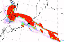
A large cloud of sulfur dioxide stretched across the Northern Pacific Ocean following the eruption of Sarychev Peak Volcano in mid-June 2009.
Published Jun 18, 2009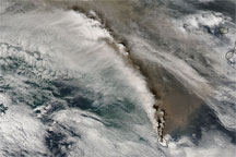
A true-color MODIS image shows water vapor and volcanic ash erupting from Sarychev Peak and forming a counter-clockwise arc over the Sea of Okhotsk on June 16, 2009.
Published Jun 16, 2009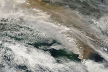
This true-color MODIS image shows ash plumes from Sarychev Peak blowing across the Sea of Okhotsk and the island of Sakhalin.
Published Jun 16, 2009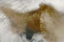
This series of images shows morning and afternoon views of the ash clouds from Sarychev Volcano on June 14 and 15, 2009.
Published Jun 16, 2009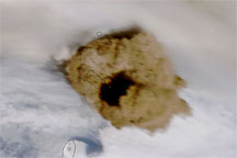
A true-color image of Sarychev Peak on June 15, 2009, shows remnants of older ash plumes and a new eruption from the volcano.
Published Jun 15, 2009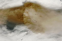
This true-color image of the plume from Sarychev Peak on June 14, 2009, shows intense volcanic ash concentrations west of the volcano, and ash spreading both east and west of the summit.
Published Jun 14, 2009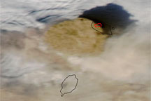
A true-color image from June 13, 2004, shows a high-profile ash plume from Sarychev Peak casting a large shadow to the north.
Published Jun 13, 2009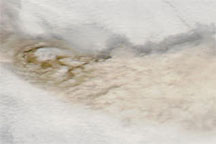
True-color images of the Central Kuril Islands show ash plumes from Sarychev Peak hovering over a blanket of clouds in early June 2009, and a clear-sky view of the same region acquired a month earlier.
Published Jun 12, 2009