The Cathedral Fire in Wilson’s Promontory National Park left a large burn scar across the landscape. This image of the burned area was captured on March 14, 2009, the day the fire was officially declared contained.
Published Mar 19, 2009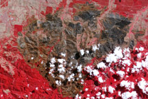
East of Churchill, Victoria, a burn scar left by one of the deadly Australian bushfires in February 2009 sprawls across the landscape in this image captured by the Advanced Spaceborne Thermal Emission and Reflection Radiometer (ASTER) on NASA’s Terra satellite on March 14.
Published Mar 18, 2009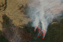
Among the remaining fires still listed as “going” in the February 25 fire status report from the Victoria Department of Sustainability and the Environment was the 158,000-hectare (390,425-acre) Killmore East-Murrundindi North fire. This image of the fire was captured on February 25.
Published Feb 25, 2009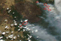
This pair of natural- and false-color images shows bushfires in Victoria on February 23, 2009.
Published Feb 23, 2009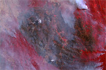
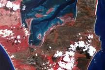
This false-color image shows the Killmore East-Murrundindi Complex North Fire in the Cathedral Range Mountains of Victoria, Australia, on February 17, 2009.
Published Feb 18, 2009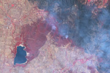
Among the areas devastated by bushfires in Victoria, Australia, in early February 2009 were Kinglake National Park and the surrounding rural and agricultural areas.
Published Feb 18, 2009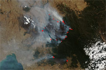
This image of the area northeast of Melbourne was captured by the Moderate Resolution Imaging Spectroradiometer (MODIS) on NASA’s Terra satellite on February 16.
Published Feb 16, 2009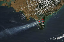
This image of a fire in Victoria’s Wilson’s Promontory National Park was captured by the Moderate Resolution Imaging Spectroradiometer (MODIS) on NASA’s Terra satellite on February 16.
Published Feb 16, 2009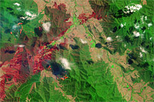
This false-color image from the Advanced Land Imager on NASA’s Earth Observing-1 satellite shows part of the 30,700-hectare (75861-acre) Beechworth Fire—which killed at least two people according to ABC news reports—on February 10, 2009.
Published Feb 14, 2009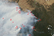
Bushfires continued in the mountains east of Melbourne, Australia, on February 13, 2009, spreading smoke over a wide area to the west.
Published Feb 13, 2009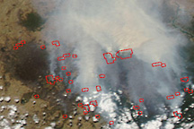
Numerous fire "hotspots" were detected in natural- and false-color images of southeastern Australia on February 9, 2009.
Published Feb 10, 2009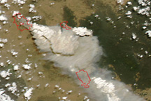
This image from the Moderate Resolution Imaging Spectroradiometer (MODIS) on NASA’s Aqua satellite shows multiple large fires (outlined in red) burning in Victoria, Australia, on February 7.
Published Feb 7, 2009