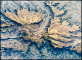
The Semien Mountains are the highest parts of the Ethiopian Plateau (more than 2,000 meters; or 6,560 feet). They are surrounded by a steep, ragged escarpment (step), with dramatic vertical cliffs, pinnacles, and rock spires. Although the plateau lies in the latitude of the Sahara–Arabia deserts, its high altitude makes for a cool, wet climate. In fact, the Semien Mountains are one of the few places in Africa to regularly receive snow, and they receive plentiful rainfall (more than 1,280 millimeters, or 55 inches). The moderate climate is shown by light green vegetation on the mountains, compared with the brown canyons, which are hot and dry.
Published Apr 7, 2008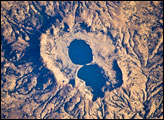
The approximately 4-kilometer-wide Dendi Caldera includes some of this silica-rich volcanic rock: the rim of the caldera, visible in this astronaut photograph, is mostly made of poorly consolidated ash erupted during the Tertiary Period (approximately 65–2 million years ago).
Published Mar 31, 2008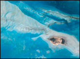
Saudi Arabia boasts the most coral reefs of any Middle Eastern country, as it includes coastline along both the Red Sea and the Persian Gulf. This high-resolution astronaut photograph shows part of the Al Wadj Bank, located along the northern Red Sea coast. Despite the relatively high salinity of Red Sea water (compared to other oceans), approximately 260 species of coral have been documented in the region.
Published Mar 24, 2008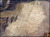
The light tan oval in this image is the floor of a lake in central Italy that has been drained by a tunnel dug through the surrounding hills. Numerous rectangular fields occupy the former lake bottom—now one of the most fertile regions of Italy. The area is still referred to as “Fucine Lake,” even though the lake has been dry for nearly 150 years.
Published Mar 17, 2008
Perhaps the most impressive of cloud formations, cumulonimbus (from the Latin for “pile” and “rain cloud”) clouds form due to vigorous convection (rising and overturning) of warm, moist, and unstable air. Surface air is warmed by the sun-heated ground surface and rises; if sufficient atmospheric moisture is present, water droplets will condense as the air mass encounters cooler air at higher altitudes. The air mass itself also expands and cools as it rises due to decreasing atmospheric pressure, a process known as adiabatic cooling. This type of convection is common in tropical latitudes year-round and during the summer season at higher latitudes.
Published Mar 10, 2008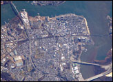
Originally known simply as “Amboy,” “Perth” was added to the name in honor of the Earl of Perth when the city became the capital of East Jersey in 1686. Together with South Amboy across the Raritan River, both cities are collectively known today as “the Amboys.” Perth Amboy is currently undergoing urban renewal and redevelopment to resume its former status as a resort destination.
Published Mar 3, 2008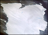
The mega-iceberg A53a (upper image) measured close to 50 kilometers by 22 kilometers, about seven times the area of Manhattan Island, in mid-January 2008 when astronauts took the photographs for this mosaic. The images were acquired from the International Space Station (ISS), located 780 kilometers to the north of the iceberg at an altitude of 341 kilometers; the perspective distorts the oblong shape of the iceberg, making it look squarer than it actually is.
Published Feb 25, 2008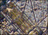
A crisp, clear winter day over France provided the International Space Station a detailed view of the city of Paris. This image shows the recognizable street pattern of the city—and some of the world’s most notable landmarks—along the Seine River.
Published Feb 18, 2008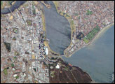
Perth is the capital of the state of Western Australia, and it is the largest city of the southwestern part of the continent, with an estimated population of over 1.5 million (as of December 2006). The downtown area of Perth and the surrounding suburbs are located on flood plain deposits of the Swan and Canning Rivers, which flow through the center of the metropolitan area. Perth enjoys a Mediterranean climate, where the summers are hot and dry, and winters are cool and moist.
Published Feb 11, 2008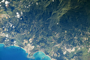
The Luquillo Mountains are located in the northeastern portion of Puerto Rico, and they rise to elevations of 1,075 meters (about 3,527 feet). Higher elevations receive more rainfall than lower elevations, leading to subtropical forest types in the lowlands and high-mountain forest types near the summits. This astronaut photograph, taken during the rainy season, illustrates the rich vegetation on the mountains.
Published Feb 4, 2008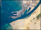
The Port of Suez is located in Egypt along the northern coastline of the Gulf of Suez. The port and city mark the southern terminus of the Suez Canal, which runs north-south through Egypt from the Mediterranean Sea to the Gulf of Suez.
Published Jan 28, 2008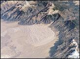
The Sangre de Cristo Mountains of south-central Colorado stretch dramatically from top left to lower right of this astronaut photograph. The mountains are outlined by dark green forests at lower elevations and white, snow-capped peaks at the highest elevations. Dun-colored dunes are banked up on the west side of the mountains. These dunes make up the Great Sand Dunes National Park and Preserve.
Published Jan 21, 2008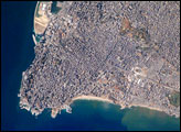
The capital of Lebanon, Beirut, is located along the southeastern shoreline of the Mediterranean Sea. The metropolitan area is built on a small peninsula composed mainly of sedimentary rock deposited over the past 100 million years or so. The growth of the city eastwards is bounded by foothills of the more mountainous interior of Lebanon.
Published Jan 14, 2008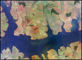
The São Simão Reservoir, near the confluence of the Rio Paranaiba and Rio Verde in Brazil, is the featured subject in a milestone image of Earth. This colorful, patchwork image is the 300,000th image of Earth downlinked from the International Space Station (ISS). The astronaut photography collection now includes more than 745,000 images of Earth taken by astronaut crews, beginning with the Mercury missions in 1961 and continuing to the present day on the ISS.
Published Jan 7, 2008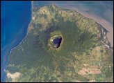
Three Central American countries—El Salvador, Honduras, and Nicaragua—have coastline along the Gulf of Fonseca, which opens into the Pacific Ocean. The southern boundary of the Gulf is a peninsula formed by the Cosigüina Volcano. Cosigüina is a stratovolcano, which is a cone-shaped volcano formed by alternating layers of solidified lava and volcanic rocks produced by explosive eruptions.
Published Dec 31, 2007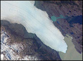
Tyndall Glacier is located in the Torres del Paine National Park in Chile. This glacier, which has a total area of 331 square kilometers and a length of 32 kilometers (based on 1996 measurements), begins in the Patagonian Andes Mountains to the west and terminates in Lago Geikie.
Published Dec 24, 2007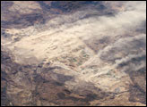
In October 2007, strong, dry Santa Ana winds raised a major dust plume and several minor plumes on the Baja California peninsula. The light brown dust spread west to the Pacific Ocean (image top right). Because they are warm, dry, and strong, Santa Ana winds reduce soil moisture and famously promote dust storms such as this.
Published Dec 17, 2007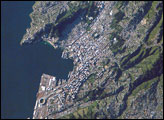
New Zealand’s capital, Wellington, sits at the southwestern tip of North Island near the Cook Strait. The city in the second largest in New Zealand (after Auckland), and at 41 south latitude, it is the southernmost capital city in the world. The North and South Islands of New Zealand are located along the active Australian-Pacific tectonic plate boundary. The glancing collision of these two tectonic plates results in uplift of the land surface, expressed as low hills on North Island and the Southern Alps on South Island.
Published Dec 9, 2007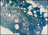
Marsh Island, located along the southwestern coastline of Louisiana, is a remnant of an abandoned lobe of the Mississippi River Delta formed approximately 5,000–7,500 years ago. It is composed primarily of organic-rich muds and brackish marsh vegetation, but some peat (layers of vegetation that have partially decomposed while submerged in water) is also present.
Published Dec 3, 2007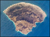
The small island of Blanquilla is named for its white sand beaches, visible in this astronaut photograph as a bright border along the northeastern–eastern shoreline. Surface currents extending from the western coastline of the island are caused by easterly trade winds. This dominant wind has also caused movement of beach sand to form white “fingers” extending inland along the east coast.
Published Nov 26, 2007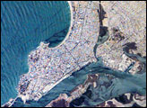
Mazatlán is Mexico’s largest port, situated on one of the best estuaries (bottom center of image) on Mexico’s Pacific coast. The city appears as a series of light-toned geometric blocks covering the center of this astronaut photograph. The image also shows the docks and naval yards that line the north side of the estuary. Mazatlán (population 352,000 in 2005) is growing northward from the downtown peninsula, with tourist beaches backed by hotels, and a marina and golf courses just beyond. No city growth yet appears on the south side of the estuary, where narrow rectangles of farm land can be seen.
Published Nov 19, 2007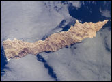
Located in the northern Gulf of California, Isla (island) San Lorenzo and Isla Las Animas—part of the Midriff Islands—record geologic processes involved in the creation of the Baja California peninsula over several hundred million years. This astronaut photograph illustrates the largely pristine nature of these islands. The islands are located in the rain shadow of mountains on the Baja Peninsula to the west, and arid conditions prevail through much of the year. The scarcity of water has limited human presence on the islands, and allowed flora and fauna unique to each island to flourish, particularly reptiles.
Published Nov 12, 2007
stronauts aboard the International Space Station (ISS) took this image of a major dust storm (image center and right) along the east side of the Aral Sea while passing over central Asia in the spring of 2007. The white, irregular lines along the bottom of the image are salt and clay deposits on the present coastline. The day that the ISS crew shot the image, winds were blowing from the west (lower left).
Published Nov 5, 2007
This astronaut photograph highlights a portion of the Saskatchewan River delta extending into Cedar Lake in the province of Manitoba, Canada. The Saskatchewan River watershed extends from the Rocky Mountains of Alberta through the plains of Saskatchewan and Manitoba to the east. Flooding of the Cedar Lake basin following the construction of the Grand Rapids Dam (to the southeast, not shown) in the 1960s created shallow, muddy lakes and bogs (dark green and blue irregular areas).
Published Oct 29, 2007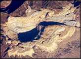
The Bingham Canyon Mine is one of the largest open-pit mines in the world, measuring over 4 kilometers wide and 1,200 meters deep. Mining first began in Bingham Canyon in the late nineteenth century, when shafts were sunk to remove gold, silver, and lead deposits that played out by the early 1900s. It would take the advent of open-pit mining in 1899 to turn the Bingham copper deposit into an economically favorable resource.
Published Oct 22, 2007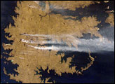
The Falkland Islands are an overseas territory of the United Kingdom, referred to by Argentina (which also claims the islands) as the Islas Malvinas. Falkland Sound, which is 12 kilometers (7.5 miles) wide at the narrow point, separates the main islands of East Falkland (image center) and West Falkland (along image left). Together they total about the same area as Connecticut or Northern Ireland. The islands lie almost 500 kilometers (310 miles) from the Argentine coast and less than 1,000 kilometers (620 miles) from Antarctica. The first flights to these remote islands were only implemented in 1971.
Published Oct 15, 2007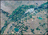
Lake McConaughy and a tan-and-green patchwork of thousands of agricultural fields dominate this astronaut photo of western Nebraska and northeastern Colorado. The astronaut who shot this view was looking towards the east-northeast, focusing on the thin, green lines of the floodplains of the North and South Platte rivers. These join to form the Platte River near image upper right.
Published Oct 8, 2007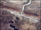
In the northwest corner of Colorado, the west-flowing Yampa River meets the south-flowing Green River, which runs into Utah. Stretches of both river canyons upstream and downstream from the junction make up Dinosaur National Monument. The monument takes its name, of course, from the abundant fossils found in exposed valleys and low ridges of the Morrison Formation, a series of rock layers that were formed late in the Jurassic Period, roughly 145 million years ago.
Published Oct 1, 2007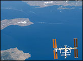
An astronaut shot this photograph while looking back across the length of Endeavour.
Published Sep 24, 2007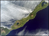
Simushir is a deserted, 5-mile-wide volcanic island in the Kuril Islands chain, half way between northern Japan and the Kamchatka Peninsula of Russia. Four volcanoes—Milne, Prevo, Urataman, and Zavaritski—have built cones tall enough to rise above the green forest. The remaining remnant of Zavaritski Volcano is a caldera, formed when a volcano collapses into its emptied magma chamber.
Published Sep 17, 2007