The extensive flooding that surrounded Normanton, Australia, had largely subsided by March 25, 2009, when the Advanced Land Imager on the EO-1 satellite captured this image.
Published Mar 25, 2009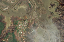
This pair of natural-color and infrared-enhanced images from the Advanced Land Imager (ALI) on NASA’s Earth Observing-1 (EO-1) satellite reveal that floods still surrounded much of the Queensland town of Normanton on the morning of March 12, 2009.
Published Mar 14, 2009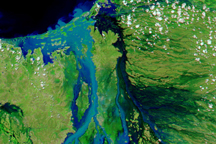
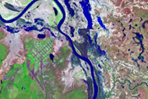
The Flinders River in northern Queensland, Australia, spread over more than 100 kilometers on February 18, 2009, when this image was taken.
Published Feb 21, 2009
Flood waters nearly surround the tiny town of Normanton, Australia in this satellite image.
Published Feb 20, 2009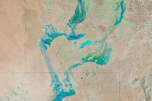
Water flowed through Australia’s Channel Country on February 18, 2009, as seasonal rivers and wetlands filled in response to seasonal rains in Australia's north.
Published Feb 18, 2009
During the first two weeks of January 2009, torrential rains brought both drought relief and severe flooding to parts of Queensland and Northern Territory in northern Australia.
Published Jan 14, 2009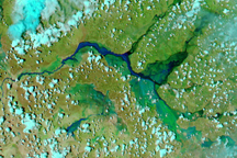
Drenching wet-season rains led to extensive flooding in Northern Territory and Queensland, Australia in early January 2009.
Published Jan 6, 2009