The recent discovery of the Mammerickx Microplate was made possible by new satellite-derived maps of the ocean floor.
Published Jan 13, 2016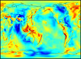
The Gravity Recovery and Climate Experiment (GRACE) has released its first science product: the most accurate map yet of Earth’s gravity field.
Published Jul 30, 2003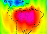

Scientists from NASA are cruising on a research vessel from Tasmania to Tahiti by way of the Southern Ocean. Their objective: gather detailed measurements of Pacific sea water that will be used to validate satellite measurements
Published Apr 5, 2014
The first image released from the Gravity Recovery and Climate Experiment (GRACE), a joint NASA-German Aerospace Center mission, graphically illustrates the sensitivity of the mission’s twin spacecraft to changes in Earth’s gravity
Published Dec 11, 2002
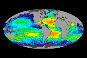
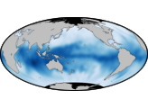
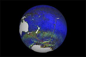
One year after its launch, the Aquarius instrument is giving ocean sciences its first global view of sea surface salinity.
Published Jun 12, 2012
The GRACE satellites can detect the movement and depletion of water supplies at and below Earth’s surface.
Published Sep 20, 2012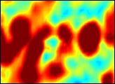
Submerged in the Atlantic Ocean off the coast of Spain and Portugal are giant, salty whirlpools of warm water. These deep-water whirlpools are part of the ocean’s circulatory system, and they help drive the ocean currents that moderate Earth’s climate. Warm water ordinarily sits at the ocean’s surface, but the warm water flowing out of the Mediterranean Sea is so salty (and therefore dense) that when it enters the Atlantic Ocean at the Strait of Gibraltar, it sinks to depths of more than 1,000 meters (one-half mile) along the continental shelf. This underwater river then separates into clockwise-flowing eddies that may continue to spin westward for more than two years, often coalescing with other eddies to form giant, salty whirlpools that may stretch for hundreds of miles. Because the eddies originate from the Mediterranean Sea, scientists call them “Meddies.”
Published Mar 23, 2006