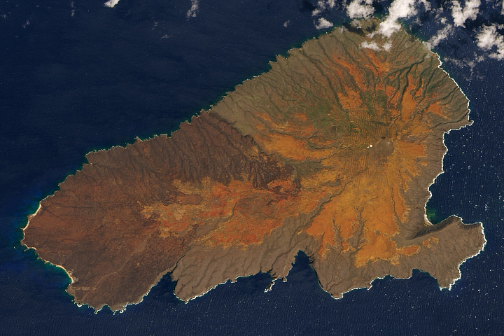
The Hawaiian island has been scarred by volcanic eruptions, livestock grazing, penal colonies, bombs, and fire. Yet there is hope for healing.
Published Mar 23, 2020
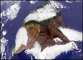
Despite sporadic rainfall, the island is the occasional home of two of the larger bodies of water in Hawaii.
Published Apr 5, 2020
As the highest volcano on the island of Hawaii, it is an ideal location for astronomical observatories.
Published Nov 30, 2015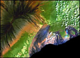
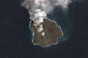
Nishinoshima spews a plume of ash and gas, part of an ongoing eruption that continues to increase the size of the small island.
Published Mar 5, 2015
In the western Pacific Ocean, a new volcanic island that formed in the shadow of Nishino-shima has merged with it. The island has doubled in size as the eruption continues.
Published Apr 4, 2014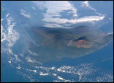
An oblique view (the astronaut was looking towards the southwest, rather than straight down) of the Hawaiian Islands taken from the International Space Station on a hazy spring day includes a regional view of three volcanic plumes from Kilauea that contributed to the vog: the plume from Halema’uma’u crater, from the Pu’u O’o vent along the east rift, and a plume from where lava enters the ocean on the coast.
Published Jun 2, 2008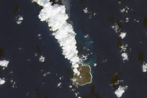
More than a year after emerging from the Pacific Ocean, a new Japanese island continues to grow.
Published Dec 2, 2014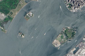
A pair of modest oyster flats turned into two of most important islands in the United States.
Published Mar 20, 2016
The most interesting geology lies just offshore and below the water line of this Northwest Australian island.
Published Aug 3, 2015

The ghostly white shapes northeast and immediately southwest of Wrangel Island are sea ice. Over the course of the satellite record, Arctic sea ice has advanced and retreated past Wrangel Island many times. From 1979 to 2000, the sea ice edge at the end of summer generally fell somewhere in the vicinity of Wrangel Island, but this is not the first summer when the sea ice edge has retreated well north of the island.
Published Aug 29, 2008
Named Isla de Aves in Spanish, (meaning “Island of the Birds”) Aves Island lies west of the Lesser Antilles in the Caribbean. It provides a nesting site to green sea turtles (Chelonia mydas) and, of course, birds. Because the abundant bird droppings, known as guano, could be used in fertilizer and gunpowder, guano miners worked on the island until they depleted the supply. Since its discovery by Europeans, likely in the late 16th century, Aves Island was subsequently claimed by several European nations. The island is currently claimed by Venezuela, although disputes about ownership of the island, and the surrounding exclusive economic zone in the Caribbean, continue today.
Published Jun 19, 2006
This astronaut photograph shows the southern end of Paramushir Island after a snowfall. Four volcanic centers are brightly lit on their western slopes and deeply shadowed to the east.
Published Jul 12, 2010
On September 25, 2002, astronauts aboard the International Space Station viewed Easter Island, one of the most remote locations on Earth. Easter Island is more than 2000 miles from the closest populations on Tahiti and Chile—even more remote than astronauts orbiting at 210 nautical miles above the Earth. Archaeologists believe the island was discovered and colonized by Polynesians at about 400 AD. Subsequently, a unique culture developed. The human population grew to levels that could not be sustained by the island. A civil war resulted, and the island’s deforestation and ecosystem collapse was nearly complete.
Published Oct 6, 2002
