Images related to Typhoons Mitag and Hagibis Drench the Philippines

Typhoon Muifa
Image

Typhoon Muifa

Published Nov 19, 2004

Severe Storms

Tropical Storm Conson
Image

Tropical Storm Conson

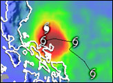
This color-coded image shows rainfall amounts and the storm track associated with Tropical Storm / Typhoon Conson from July 12–18, 2010.

Published Jul 19, 2010

Atmosphere Severe Storms

Rainfall from Typhoon Kai-tak
Image

Rainfall from Typhoon Kai-tak

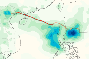
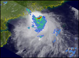
This color-coded image shows rainfall totals and the storm track for Typhoon Kai-tak in August 2012.

Published Aug 20, 2012

Atmosphere Water Severe Storms

Tropical Storm Parma
Image

Tropical Storm Parma

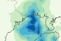
This image shows Parma’s path between October 4 and 14, 2009. It also shows regional rainfall between October 8 and 14.

Published Oct 15, 2009

Atmosphere Severe Storms

Typhoon Nesat
Image

Typhoon Nesat

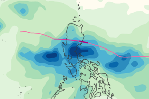
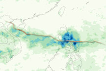
A swath of heavy rain defines the track of Typhoon Nesat in this rainfall map.

Published Sep 28, 2011

Atmosphere Land Water Severe Storms

Typhoon Xangsane
Image

Typhoon Xangsane

Published Oct 6, 2006

Severe Storms

Tropical Storm Kompasu
Image

Tropical Storm Kompasu

Published Jul 19, 2004

Severe Storms

Tropical Storm Bilis
Image

Tropical Storm Bilis

Published Jul 14, 2006

Severe Storms

Heavy Rains in Philippines
Image

Heavy Rains in Philippines

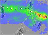
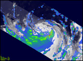
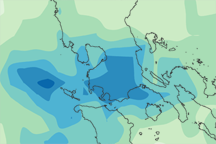
This analysis shows rainfall estimates for Manila and the surrounding region from September 21 to 27, 2009. The heaviest rainfall amounts appear in blue and the lightest amounts appear in pale green. Gray shading indicates topography.

Published Sep 29, 2009

Image of the Day Atmosphere Land Floods Human Presence