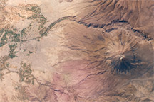
This astronaut photograph from October 16, 2009, shows Arequipa—Peru’ “White City”on the flanks of the towering El Misti Volcano.
Published Nov 2, 2009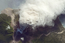
An oblique photo of Montserrat Island taken by astronauts captures an eruption from the island’s Soufrière Hills Volcano on October 11, 2009.
Published Oct 19, 2009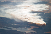
The smoke plume from the Arnica Fire is reflected in Yellowstone Lake in this astronaut photo from September 24, 2009.
Published Oct 12, 2009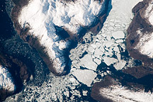
This astronaut photograph shows the merged outlet of two glaciers within the deep fjords of the Southern Patagonian Ice Field.
Published Oct 5, 2009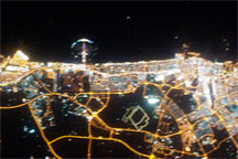
This nighttime astronaut photo shows the city lights of Dubai in the United Arab Emirates on September 11, 2009.
Published Sep 28, 2009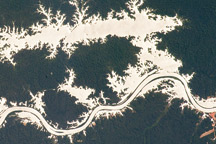
In this astronaut photo, the mirror-like reflection of sunlight off water makes the Trombetas River and Lake Erepecu in the Brazilian Amazon stand out from the deep green forest.
Published Sep 21, 2009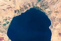
This astronaut photo of Israel’s Lake Tiberias (Sea of Galilee) shows an irregular patchwork of green and brown fields surrounding the lake. The Jordan River is visible flowing in at the northern end of the lake and out at the southern end.
Published Sep 14, 2009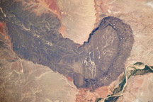
The otherworldly footprint of black basaltic lava creates a striking landscape at Black Point Lava Flow in northern Arizona, seen in this photograph taken from the International Space Station.
Published Sep 7, 2009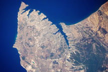
The urban landscape of Sevastopol, on the Ukrainian coast of the Black Sea, is featured in this astronaut photo from August 5, 2009.
Published Aug 24, 2009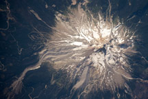
In the astronaut photo from August 5, 2009, bright white glaciers cap the summit of Oregon’s Mount Hood, while gray volcanic deposits line the rivers that drain the mountain, and green forests cover the lower slopes.
Published Aug 17, 2009
Forty years after the Apollo 11 landing on the Moon, the Lunar Reconnaissance Orbiter captured this image of the descent stage of the Eagle lunar module.
Published Jul 20, 2009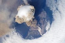
A fortuitous orbit of the International Space Station in 2009 offered the astronauts a striking view of the volcano in an early stage of eruption.
Published Jun 22, 2009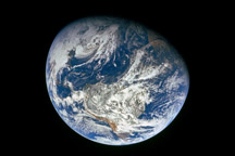
This stunning photo came back to Earth with the Apollo 8 astronauts in late December 1968.
Published Nov 27, 2008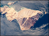
Located in the Bahia de los Angeles, Isla Coronado sits in the Gulf of California, just off the eastern shoreline of Mexico’s Baja Peninsula. The island is approximately 7 kilometers long, and it is dominated by Volcan Coronado on the northern end.
Published Oct 20, 2008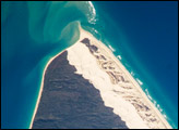
Fraser Island, the world’s largest sand island, is located along the coastline of Queensland, Australia, and it includes Great Sandy National Park. The island was designated a World Heritage site in 1992, in part due to its outstanding preservation of geological processes related to sand dune formation.
Published Oct 13, 2008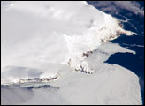
Bouvet Island is known as the most remote island in the world; Antarctica, over 1600 kilometers (994 miles) to the south, is the nearest land mass. Located near the junction between the South American, African, and Antarctic tectonic plates, the island is mostly formed from a shield volcano—a broad, gently sloping cone formed by thin, fluid lavas—that is almost entirely covered by glaciers.
Published Oct 6, 2008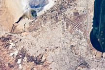
The urban area of Tunis is located on a flat coastal plain, and is distinguished in this astronaut photograph from the surrounding desert by the pattern of grey and tan buildings and the dark street grid. The city is bordered by an evaporating saline lake to the northeast known as Sebkhet Arina (upper left).
Published Sep 22, 2008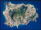
he island of Ischia is approximately 30 kilometers southwest of Naples, Italy, in the western Bay of Naples (part of the Tyrrenhian Sea). While the island’s rocks are volcanic in origin, much of the island’s geology and current topography is characterized by blocks of uplifted rock and sunken areas between weak spots or cracks in Earth’s crust.
Published Sep 15, 2008
The setting sun glints off the Amazon River and numerous lakes in its floodplain in this astronaut photograph from August 19, 2008. Large areas of sunglint are common in oblique views. Sunglint images reveal great detail in surface water—in this case the marked difference between the smooth outline of the Amazon and the jagged shoreline of the Uatumã River.
Published Sep 8, 2008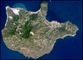
The Aeolian Islands formed from a chain of volcanoes in the Tyrrhenian Sea north of the island of Sicily. Geologists and volcanologists have studied the islands since the eighteenth century, and the United Nations Educational, Scientific, and Cultural Organization (UNESCO) declared them a World Heritage Site in 2000 because of their value to the study of volcanic processes.
Published Sep 1, 2008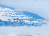
The image is highly oblique—taken from an angle looking outwards from the ISS, rather than straight down towards the Earth—and this perspective provides a sense of topography along the southern edge of Greenland. The exposed dark grey bedrock along the southwestern coastline has been carved by glaciers into numerous fjords, steep-sided valleys that drain directly into the ocean.
Published Aug 25, 2008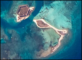
The Dry Tortugas are a group of islands located approximately 75 miles west of Key West, Florida; they form the western end of the Florida Keys in the Gulf of Mexico. This astronaut photograph highlights three islands in the group: Bush Key, Hospital Key, and Garden Key, which is the site of Fort Jefferson, a Civil War-era fort.
Published Aug 18, 2008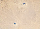
While the pyramids of Giza are perhaps the most famous, there are several other ancient Egyptian royal necropolis (“city of the dead”) sites situated along the Nile River and its delta. One of these sites is near the village of Dashur, illustrated in this astronaut photograph.
Published Aug 11, 2008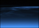
Polar mesospheric clouds (also known as noctilucent, or “night-shining” clouds) are transient, upper atmospheric phenomena that are usually observed in the summer months at high latitudes (greater than 50 degrees) of both the Northern and Southern Hemispheres. They appear bright and cloudlike while in deep twilight. They are illuminated by sunlight when the lower layers of the atmosphere are in the darkness of Earth’s shadow.
Published Aug 4, 2008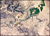
This detailed astronaut photograph depicts a portion of the Gila River channel in south-central Arizona. The northernmost boundary of the Sentinel Volcanic Field is visible in the image, recognizable by the irregular flow fronts of thin basalt lava flows. Active agricultural fields along the Gila River are a rich green set against the surrounding desert.
Published Jul 28, 2008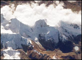
This astronaut photograph was taken looking east as the International Space Station was flying about 100 kilometers (about 62 miles) off the Peruvian coast and shows Cordillera Huayhuash (pronounced “Why-wash”).
Published Jul 21, 2008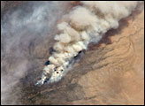
The Piute Fire, burning south of Lake Isabella in the Sequoia National Forest in the southern Sierra Nevada Mountains, was one of the more than 300 wildfires burning across the state of California in early July 2008.
Published Jul 14, 2008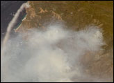
One of the largest and most destructive fires raging across California over the weekend of July 4 was the Basin Fire, threatening Big Sur, and covering the coast in a thick blanket of smoke.
Published Jul 10, 2008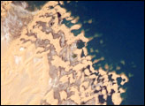
In the late 1990s, Egypt’s new manmade Toshka Lakes, fed from Lake Nasser via a canal, grew and spilled into new basins to become four major and two smaller lakes. Starting in 2002, astronauts have seen the lakes slowly decline, with the telltale ring of darker, moistened ground showing the previous higher water levels.
Published Jul 7, 2008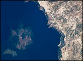
One of the largest volcanic eruptions in the past 10,000 years occurred in approximately 1620 BC on the volcanic island of Santorini in the Aegean Sea. This astronaut photograph illustrates the center of Santorini Volcano, located approximately 118 kilometers to the north of Crete.
Published Jun 30, 2008