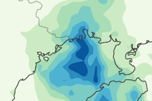
This image shows Parma’s path between October 4 and 14, 2009. It also shows regional rainfall between October 8 and 14.
Published Oct 15, 2009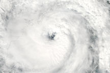
Acquired October 13, 2009, this true-color image shows Tropical Storm Parma hovering over the Gulf of Tongking, between Hainan and Vietnam.
Published Oct 13, 2009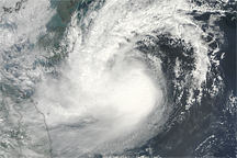
Acquired October 11, 2009, this true-color image shows tropical storm Parma slowly approaching southern China and Vietnam.
Published Oct 12, 2009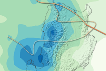
Typhoon Parma dumped up to 700 millimeters of rain over northern Luzon, Philippines, over the course of a week, as illustrated in this map of rainfall totals between October 2 and October 8, 2009.
Published Oct 10, 2009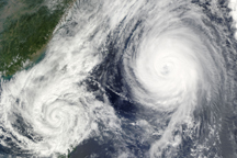
A little over 1,000 kilometers separated the center of Tropical Storm Parma from the center of Typhoon Melor on October 6, when the this composite image was taken.
Published Oct 7, 2009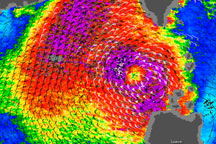
As this wind speed image illustrates, Tropical Storm Parma still had a core of strong winds on October 5, 2009.
Published Oct 5, 2009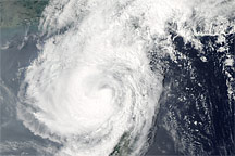
Acquired October 5, 2009, this true-color image shows Tropical Storm Parma west of the islands of Luzon and Taiwan.
Published Oct 5, 2009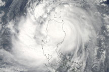
Acquired October 3, 2009, this true-color image shows Typhoon Parma hovering over the island of Luzon. Storm clouds stretch from the Philippine Sea to the South China Sea.
Published Oct 4, 2009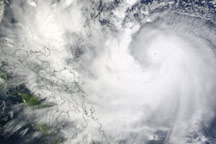
Acquired October 1, 2009, this true-color image shows Typhoon Parma headed westward over the Pacific Ocean. Outlined in black in the left half of the image are parts of the Philippines.
Published Oct 1, 2009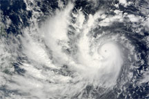
Acquired September 30, 2009, this true-color image shows Typhoon Parma over the Pacific Ocean, west of the Philippines.
Published Sep 30, 2009