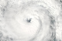

Typhoon Parma headed westward over the Pacific Ocean, en route to the northern Philippines on September 30, 2009. The Moderate Resolution Imaging Spectroradiometer (MODIS) on NASA’s Terra satellite captured this true-color image the same day. Parma’s eye appears in the right half of this image, and the storm appears to throw long arms toward the northwestwest.
A September 30 report from the Joint Typhoon Warning Center stated that Parma had maximum sustained winds of 75 knots (roughly 140 kilometers per hour) with gusts up to 90 knots (almost 170 kilometers per hour). The storm was expected to overlap the northern Philippines, already reeling from the worst floods in decades brought by Tropical Storm Ketsana.
NASA image created by Jesse Allen, using data provided courtesy of the MODIS Rapid Response team. Caption by Michon Scott.
Atmosphere Water Severe Storms
Acquired September 30, 2009, this true-color image shows Typhoon Parma over the Pacific Ocean, west of the Philippines.
Typhoon Parma moved westward across the Pacific Ocean in late September 2009. Parma was downgraded to a tropical storm as it passed over the Philippines, but moved back toward the islands, apparently interacting with Typhoon Melor to the northeast. Parma finally dissipated on October 14.


