Images related to NASA’s Eyes on Nepartak

Typhoon Soudelor Takes Aim at Taiwan
Image

Typhoon Soudelor Takes Aim at Taiwan

The storm has central Taiwan in its sights.

Published Aug 8, 2015

Image of the Day Severe Storms Remote Sensing

Rapid Response for a New Wind Instrument
Image

Rapid Response for a New Wind Instrument

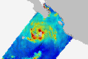
Barely two weeks after its launch and two days after its installation, the ISS-Rapid Scatterometer observed the wind field around a tropical storm.

Published Oct 8, 2014

Image of the Day Atmosphere Water

Typhoon Chan-hom
Image

Typhoon Chan-hom

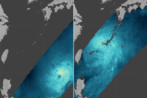
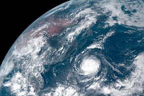
The storm grew from a Category 1 to a Category 4 typhoon as it pushed toward the coast of China.

Published Jul 11, 2015

Image of the Day Water

Assessing Haiyan’s Winds
Image

Assessing Haiyan’s Winds

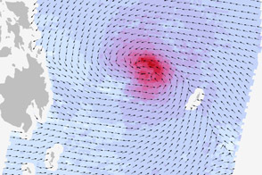
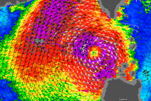
A radar on the Indian satellite Oceansat-2 measured the winds of the super typhoon on November 7, 2013.

Published Nov 13, 2013

Image of the Day Atmosphere Severe Storms

Sub-tropical Storm Laura
Image

Sub-tropical Storm Laura

Published Sep 30, 2008

Severe Storms

Hurricane Bill
Image

Hurricane Bill

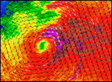
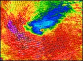
Strong winds and heavy rain are revealed near the eye of Hurricane Bill in this QuikSCAT satellite image from August 16, 2009.

Published Aug 17, 2009

Atmosphere Water Severe Storms

Hurricane Katrina
Image

Hurricane Katrina

Published Aug 25, 2005

Severe Storms

Typhoon Parma
Image

Typhoon Parma

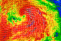
As this wind speed image illustrates, Tropical Storm Parma still had a core of strong winds on October 5, 2009.

Published Oct 5, 2009

Atmosphere Water Severe Storms

Tropical Cyclone Percy
Image

Tropical Cyclone Percy

Published Mar 4, 2005

Severe Storms

Tropical Storm Bebinca
Image

Tropical Storm Bebinca

Published Oct 5, 2006

Severe Storms