Over the course of 25 years, farms have sprouted in the Arabian Desert, fueled by deep and old groundwater.
Published May 12, 2012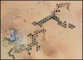
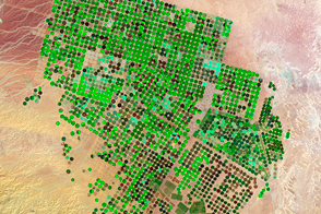
Green circles in the desert frequently indicate tracts of agriculture supported by center-pivot irrigation. The Al Khufrah Oasis in southeastern Libya (near the Egyptian border) is one of Libya’s largest agricultural projects, and is an easy-to-recognize landmark for orbiting astronauts aboard the International Space Station. Because only about 2 percent of Libya’s land receives enough rainfall to be cultivated, this project uses fossil water from a large underground aquifer. The Libyan government also has a plan called the Great Man Made River to pump and transport these groundwater reserves to the coast to support Libya’s growing population and industrial development.
Published Nov 15, 2004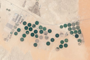
Satellites can help farmers make the most of the limited water resources at a farm in the Arabian Desert.
Published Jun 20, 2015
Water from the Kaidu River made it possible to turn part of the Taklamakan Desert into an oasis for agriculture, but it has also disturbed the water table.
Published Aug 18, 2012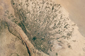
Clusters of dark green fields stretch away from the hills like fingers across this alluvial fan in Afghanistan.
Published Aug 1, 2016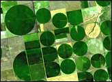

For more than 100 years, groups in the western United States have fought over water. During the 1880s, sheep ranchers and cattle ranchers argued over drinking water for their livestock on the high plains. In 1913, the city of Los Angeles began to draw water away from small agricultural communities in Owen Valley, leaving a dusty dry lake bed. In the late 1950s, construction of the Glen Canyon Dam catalyzed the American environmental movement. Today, farmers are fighting fishermen, environmentalists, and Native American tribes over the water in the Upper Klamath River Basin. The Landsat 7 satellite, launched by NASA and operated by the U.S. Geological Survey, documented an extreme drought in the area along the California/Oregon border in the spring of 2001.
Published Sep 8, 2001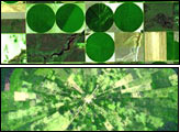
Around the world, agricultural practices have developed as a function of topography, soil type, crop type, annual rainfall, and tradition. This montage of six images from shows differences in field geometry and size in different parts of the world.
Published May 30, 2006
Natural vegetation and irrigated farmland along the Snake River Plain in Idaho use dramatically different amounts of water during the growing season.
Published Jan 26, 2010
Using Landsat to track patterns in irrigation may help water managers sketch out a more sustainable future for the Ogallala Aquifer in the central United States.
Published Jul 9, 2018
Astronauts aboard the International Space Station took this photograph when the desert center of Arabia was partly obscured by a dusty atmosphere.
Published Dec 8, 2014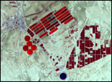
Is that a tapestry or an agricultural scene from Canada?
Published Jan 23, 2012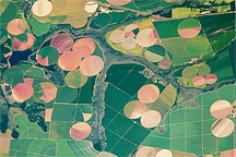
Astronaut photograph of the diverse agricultural landscape in the western part of Minas Gerais state in Brazil.
Published Feb 21, 2011