
These iconic photos are not new, but their message never gets old.
Published Dec 24, 2018
From one million miles away, the DSCOVR satellite returned its first view of the entire sunlit side of Earth.
Published Jul 21, 2015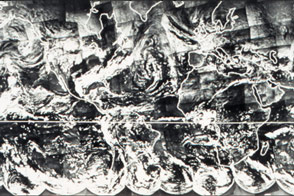
Before there was a Blue Marble photograph or composite image of Earth, there was TIROS IX.
Published Apr 22, 2015
Sixteen operating satellites monitor Earth. Four more are scheduled to launch in 2014.
Published Jul 5, 2013
The MarCO-B CubeSat snapped its first photo on May 9, 2018, and caught a glance of home.
Published May 28, 2018
On July 19, 2013, NASA spacecraft got not one but two rare and unique views of Earth from opposite ends of the solar system.
Published Jul 24, 2013
Some of the most breathtaking views of Earth taken from space are those that capture our planet’s limb.
Published Apr 2, 2003
The Curiosity rover on Mars looked up and saw home on the horizon.
Published Mar 9, 2014
When the Apollo 11 astronauts left the surface of the Moon on July 21, 1969, they brought home samples of solar wind particles, lunar rocks and dirt, and a big helping of perspective.
Published Jul 20, 2019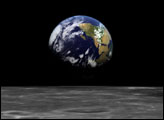
To mark the 30th anniversary of the Apollo 17 mission and the famous “Blue Marble” full Earth image, Goddard Space Flight Center’s Visualization and Analysis Lab has rendered a new visualization inspired by the mission.
Published Dec 7, 2002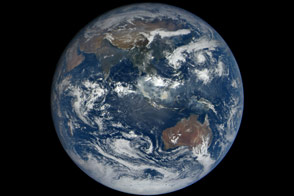
When the DSCOVR mission was conceived in the late 1990s, one of the central ideas was to provide daily, natural-color views of the entire Earth so that everyday citizens could see it. Seventeen years later, we have that view.
Published Oct 23, 2015
This true-color image shows North and South America as they would appear from 35,000 km (22,000 miles) above the Earth.
Published Oct 17, 2000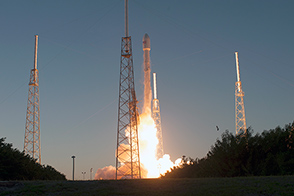
After arriving in its final orbit, DSCOVR will monitor the solar wind and send back epic views of Earth’s full sunlit disk.
Published Feb 13, 2015
Looking back from its orbit around Mercury, MESSENGER captured this view of Earth and the Moon on May 6, 2010.
Published Sep 9, 2010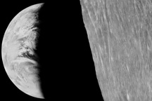
Long before man journeyed to the moon and looked back at the tiny, fragile planet that houses humanity, lunar orbiters were sending back pictures of home.
Published Nov 15, 2008
Cameras on a lunar orbiter and some clever image processing techniques led to a new take on a historic image of the Earth and Moon.
Published Dec 25, 2015
Seen from a billion kilometers away, through the ice and dust particles of Saturn’s rings, Earth appears as a tiny, bright dot.
Published Jan 16, 2007
This image of Earth was captured by the MESSENGER spacecraft during a flyby of our home planet on August 2, 2005. Parts of South and North America were in view.
Published May 8, 2009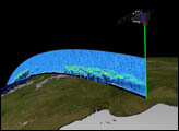
Orbiting the Earth at nearly 17,000 miles per hour, NASA's Ice, Cloud and land Elevation Satellite (ICESat) is collecting spectacular new three-dimensional measurements of the Earth's surface and atmosphere.
Published Dec 10, 2003