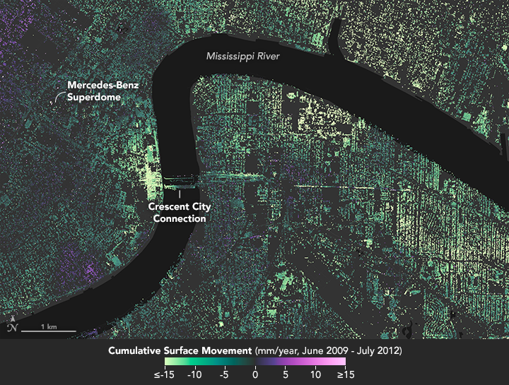


New Orleans and its surrounding areas continue to sink at highly variable rates due to a combination of natural geologic processes and human activity, according to a new study using NASA airborne radar. The observed rates of sinking, also known as subsidence, were generally consistent with, but somewhat higher than, previous studies conducted with radar data.
The maps above show how much the ground in the New Orleans area sank (subsidence) or rose (uplift) relative to its 2009 elevation, plotted in millimeters per year. Shades of green depict lands that sank, while areas in purple rose. The maps depict data collected from June 2009 to July 2012 and analyzed by a team from NASA’s Jet Propulsion Laboratory (JPL), the University of California at Los Angeles, and Louisiana State University (LSU).
The highest rates of sinking were observed upriver along the Mississippi River around major industrial areas in Norco and Michoud (shown in the downloadable large image)—with up to 50 millimeters (2 inches) of sinking per year. The team also observed notable subsidence in New Orleans' Upper and Lower 9th Ward, and in Metairie, where the ground movement could be related to water levels in the Mississippi. At the Bonnet Carré Spillway—the city’s last line of protection against springtime river floods—research showed as much as 40 millimeters (1.6 inches) a year of sinking behind the structure and at nearby industrial facilities.
While the study cites many factors for the regional subsidence, the primary contributors are groundwater pumping and dewatering—surface water pumping to lower the water table, which prevents standing water and soggy ground.
“Agencies can use these data to more effectively implement actions to remediate and reverse the effects of subsidence, improving the long-term coastal resiliency and sustainability of New Orleans,” said JPL scientist and lead author Cathleen Jones. “The more recent land elevation change rates from this study will be used to inform flood modeling and response strategies.”
A key component of the study was data from NASA’s Uninhabited Aerial Vehicle Synthetic Aperture Radar (UAVSAR), which uses a technique known as interferometric synthetic aperture radar (InSAR). InSAR compares radar images of Earth’s surface acquired over the months and years to map surface deformation with centimeter-scale precision. The technique measures total surface elevation changes from all sources—human and natural, deep seated and shallow. UAVSAR’s spatial resolution makes it ideal for measuring change in New Orleans, where human-caused subsidence can be large and often localized. “We were able to identify single structures or clusters of structures subsiding or deforming relative to the surrounding area,” Jones said.
In addition to the UAVSAR data, researchers from the Center for GeoInformatics (C4G) at LSU provided up-to-date GPS positioning information for industrial and urban locations in southeast Louisiana. This information helped establish the rate of ground movement at specific points. C4G maintains the most comprehensive network of GPS reference stations in the state, including more than 50 Continuously Operating Reference Stations, or CORS sites, that acquire the horizontal and vertical coordinates at each station every second of every day. CORS data help pin InSAR data down to specific, local points on Earth.
NASA Earth Observatory maps by Joshua Stevens, using UAVSAR data courtesy of Cathleen Jones/JPL. Caption by Alan Buis, JPL; edited by Mike Carlowicz.