
For much of 2024, thick clouds of smoke engulfed much of Bolivia—the result of record-breaking fires that raged across the region.
The MODIS (Moderate Resolution Imaging Spectroradiometer) on NASA’s Aqua satellite captured this image (right) of burn scars in Beni, a department in northern Bolivia, on November 30, 2024. The other image (left) shows the same area on May 6, 2024, before the most intense fires occurred.
In these false-color (bands 7-2-1) images, forests are green, burned areas appear yellow and orange, and surface water is shown in shades of blue. Suspended sediment in the water can alter the appearance of water bodies, with higher sediment concentrations producing lighter blue tones. Greens have been darkened to make it easier to distinguish the burned areas. The degree of regrowth, intensity of the burning, and types of fuels involved can affect the appearance of burned areas. Red areas likely burned more recently or severely than yellow areas.

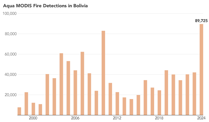
Satellites detect large numbers of fires burning in Bolivia every year, but 2024 saw a dramatic surge. The numbers of fires in the months of June, July, and September all broke records, according to an analysis of Aqua MODIS data from Brazil’s National Institute for Space Research (INPE). Overall, satellites observed a record 89,725 fires by December 3. This is the highest number of fires detected in a single year since Aqua MODIS began collecting data in 2002, surpassing the previous record of 83,119 fires in 2010.
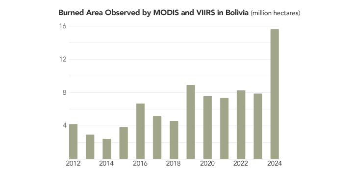
The Global Wildfire Information System (GWIS)—a fire tracking system powered by MODIS and VIIRS (Visible Infrared Imaging Radiometer Suite) satellite data—reported more than 15 million hectares burned in Bolivia in 2024, an area larger than Greece. Wildfire emissions estimates provided by the Copernicus Atmosphere Monitoring Service’s Global Fire Assimilation System, another system powered by MODIS data, put wildfire carbon emissions at more than 100 megatons, the highest in the past two decades.

Land clearing and pasture burning are common causes of fires in Bolivia. The region has also faced exceptional drought in recent months. Fires also raged across several other departments, including Pando, La Paz, and Santa Cruz, and affected various forest types, including tropical rainforests, Chiquitano dry forests, and the Gran Chaco.
NASA Earth Observatory images and charts by Michala Garrison, using MODIS data from NASA EOSDIS LANCE and GIBS/Worldview, fire detection data from INPE, and burned area data from GWIS. Story by Adam Voiland.