The Earth Observatory has published its last Image of the Day on this website. Please join us on our new home at science.nasa.gov/earth/earth-observatory.
Formed between 3.6 billion and 2.8 billion years ago, the rocks of the Pilbara Craton in Western Australia are some of the oldest on Earth. The iron-rich rocks here began forming before there was oxygen in Earth’s atmosphere or even life itself. The area also harbors evidence of some of the earliest life—3.45-billion-year-old fossil colonies of microbial cyanobacteria, the oldest known stromatolites on Earth.
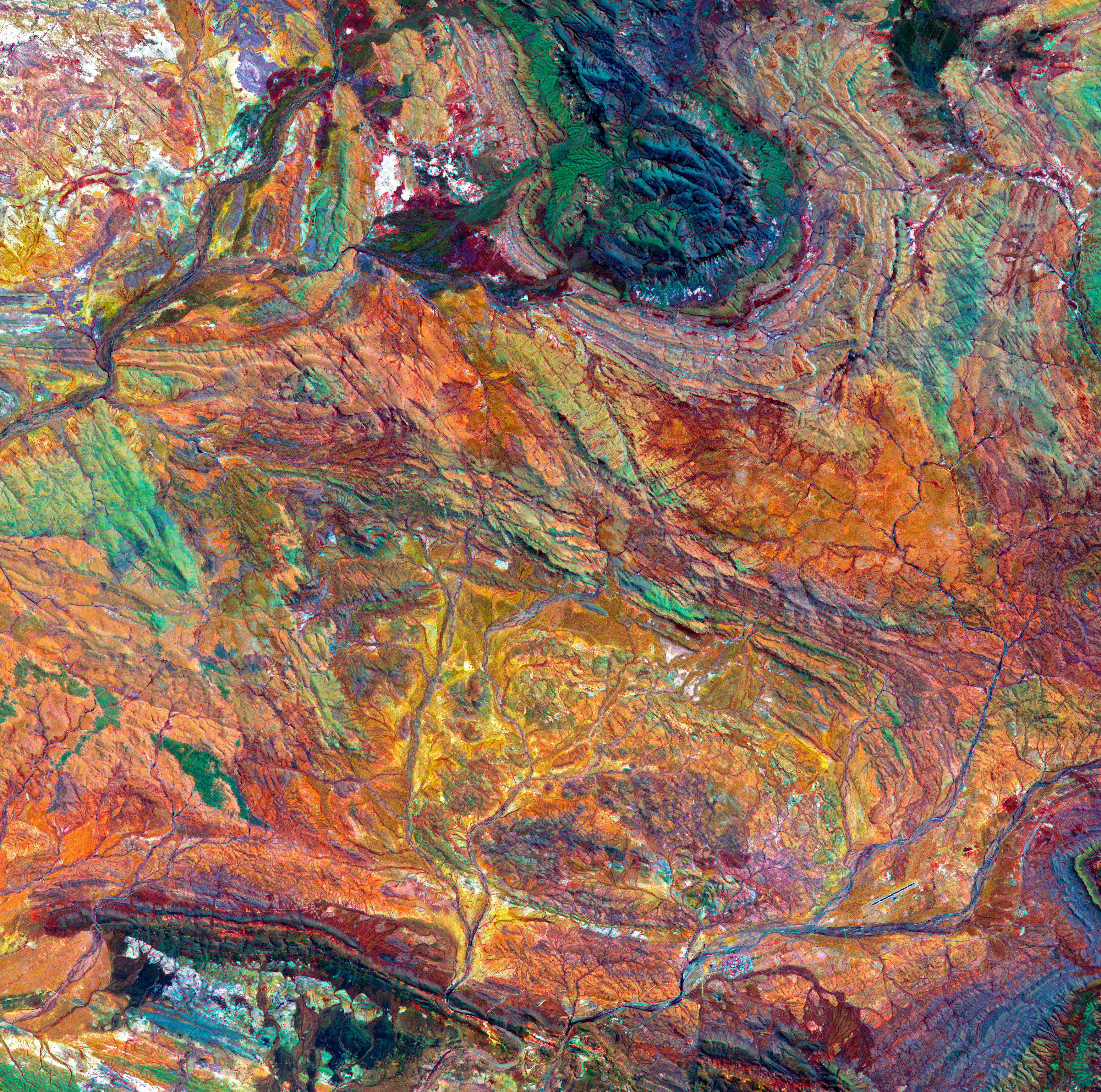
The false-color image above shows part of the Hamersley Basin in Western Australia, which lies on the southern Pilbara Craton. A craton is the stable, geologically inactive core of an ancient continent. The Pilbara Craton has remained intact, surviving the affronts of plate tectonics and erosion since the Archean Eon (4 billion to 2.5 billion years ago).
During the Archean, and the Proterozoic Eon that followed, multiple cratons assembled to form the Australian continent, leaving multiple basins and belts of buckled and folded rocks at their margins. The main cratons that formed Western Australia are the Pilbara and Yilgarn. They began to assemble about 2.2 billion years ago during a mountain-building episode called the Capricorn Orogeny.
The land that is today known as the Hamersley Basin was then at the bottom of an ocean lying between the two cratons. The rocks of the basin preserve a record of the last ocean environment in the area before the cratons converged and closed the basin.
Atop the granite and greenstone rocks of the Pilbara Craton lie the younger rocks of the Fortescue, Hamersley, and Turee groups, which were deposited between 2.7 billion and 2.3 billion years ago. Together these rocks form the Mount Bruce Supergroup, which holds a singular place in Australia’s geologic history.
According to the Geological Survey of Western Australia, not only do these rocks hold the best-preserved sequence of Archean volcanic rocks, but they also include the most continuous rock record of the transition from the Archean to the Proterozoic 2.5 billion years ago (including a record of the Great Oxidation Event). In addition, they are the most economically important ores on the Australian continent. These iron-rich rocks, including the world’s thickest and most extensive banded iron formations, form the basis of the iron-ore mining industry in the region.
The image was acquired by the Advanced Spaceborne Thermal Emission and Reflection Radiometer (ASTER) on NASA’s Terra satellite on October 12, 2004. It is a composite of ASTER bands 4-2-1. These bands detect shortwave-infrared light, near-infrared and visible red light, and green light, which are displayed as red, green, and blue, respectively. In this display, iron-rich rocks appear yellow to green. Light-colored, iron-poor rocks appear white, while dark-colored iron-poor rocks are dark blue. Areas with more vegetation cover appear dark red. This is because plants reflect more near-infrared than green light. A linear contrast stretch has also been applied to the image to enhance the color contrast and help distinguish rock types.
For example, in the top center of the image, the knob-shaped outcrop colored blue and green shows the rocks of the Hamersley Group—which includes four major banded-iron formations separated by sequences of iron-poor dolomites, shales, and volcanics.
At the top left of the image, the white area shows the southeast portion of the Rocklea Dome, which is composed of light-colored granites. The dome is the remnant core of a plunging anticline—a buckled-up ridge that tilts down into the ground. Erosion of the fold’s surface exposed the dome’s granite core, which intruded into the surrounding rock during the Archaean Eon. The dome is also visibly crosscut with basalt intrusions. To the north, these rocks underlie the Hamersley Group, but here they are exposed at the surface.
The rest of the image largely shows the area underlain by the volcanic and sedimentary rocks of the Fortescue Group. Much of this land is vegetated, mostly Spinifex grasses, shrubs, and bushes. The bottom of the image shows the town of Paraburdoo and its airport.
NASA Earth Observatory image by Joshua Stevens, using data from NASA/METI/AIST/Japan Space Systems, and the U.S./Japan ASTER Science Team. Story by Sara E. Pratt.