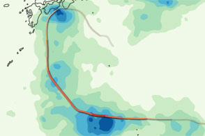
This color-coded image shows the storm track and rainfall amounts associated with Typhoon Ma-on in July 2011.
Published Jul 22, 2011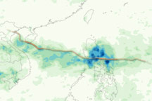
This color-coded image shows rainfall amounts and the storm track associated with Tropical Storm / Typhoon Conson from July 12–18, 2010.
Published Jul 19, 2010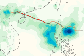
This color-coded image shows rainfall totals and the storm track for Typhoon Kai-tak in August 2012.
Published Aug 20, 2012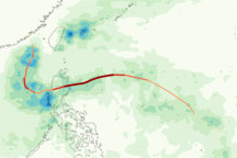
This color-coded image shows rainfall along Typhoon Megi’s path across the western Pacific between October 13 and 23, 2010.
Published Oct 26, 2010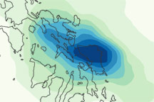
This color-coded image shows rainfall amounts over the Philippines associated with Tropical Storm Aere from May 5 to 12, 2011.
Published May 16, 2011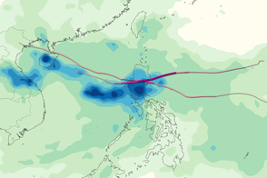
This image shows rainfall totals in the Western Pacific from September 26 to October 2, 2011, when Typhoon Nesat and Super Typhoon Nalgae caused intense flooding and other storm damage in the Philippines and southeastern Asia.
Published Oct 4, 2011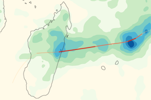
Giovanna brought heavy rains to the east coast of Madagascar, as shown in this color-coded map from early February 2012.
Published Feb 15, 2012
This color-coded map shows rainfall amounts associated with Tropical Storm Talas, the deadliest storm to strike Japan since 2004.
Published Sep 6, 2011
Acquired August 22, 2010, this image shows color-coded rainfall amounts superimposed on a photo-like image of Tropical Storm Danielle.
Published Aug 24, 2010alert message
