A second round of spring flooding on the Red River was captured in an astronaut photo from April 9, 2009.
Published Apr 27, 2009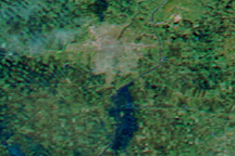
In the span of just five days, the MODIS sensor observed the snow melt and swollen rivers around Winnipeg, in Manitoba, Canada. This image shows extensive flooding on April 15, 2009.
Published Apr 16, 2009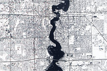
Held in place by reinforced levees, the swollen Red River snakes through Fargo, North Dakota, and Moorhead, Minnesota, in this image captured by the Advanced Land Imager on the EO-1 satellite on March 28, 2009.
Published Mar 31, 2009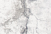
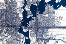
This photo-like image shows extensive flooding on the Red River near Fargo, North Dakota, on March 28, 2009 as the river reached a record high of 40.82 feet.
Published Mar 30, 2009