Images related to Regional Patterns of Sea Level Change 1993-2007

Sea Level Rise is Accelerating
Image

Sea Level Rise is Accelerating

The acceleration has been driven mainly by increased ice melting in Greenland and Antarctica, and it has the potential to double the total sea level rise projected by 2100.

Published Feb 20, 2018

Image of the Day Water Human Presence

The Rising Sea Level
Image

The Rising Sea Level

Published Jun 9, 2006

Image of the Day Water

NASA’s Front Porch View of Rising Seas
Image

NASA’s Front Porch View of Rising Seas

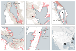
The nation’s problem is also NASA’s problem: Half to two-thirds of our space infrastructure and assets stand within 5 meters of sea level.

Published Sep 8, 2015

Image of the Day Water

The Waters are Rising on NASA’s Shores
Image

The Waters are Rising on NASA’s Shores

Global sea level rise poses very local challenges for the many NASA centers situated on U.S. coasts.

Published Sep 30, 2015

Image of the Day Land Water Human Presence Remote Sensing

Pacific Climate Calm
Image

Pacific Climate Calm

Published May 31, 2006

Image of the Day Water

A Quiet Equatorial Pacific
Image

A Quiet Equatorial Pacific

Published Nov 15, 2003

Image of the Day Water

Retreating Aral Sea Coastlines
Image

Retreating Aral Sea Coastlines

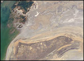
The arrow-shaped island in the Aral Sea used to be a 35-kilometer-long visual marker, indicating the Aral Sea to astronauts. An image from the present International Space Station increment shows how much the coastline has changed as the sea level has dropped during the last three decades.

Published Aug 15, 2005

Image of the Day Land

Pacific Waters Remain Stubbornly Stable
Image

Pacific Waters Remain Stubbornly Stable

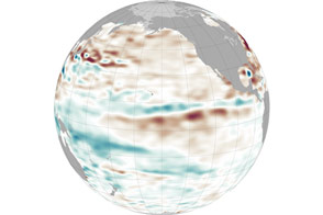
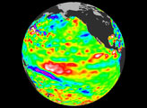
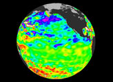
Neutral, or La Nada, conditions persist in the equatorial Pacific Ocean, frustrating climate forecasters.

Published Sep 12, 2013

Image of the Day Heat Water

El Niño Strengthening
Image

El Niño Strengthening

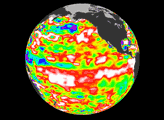
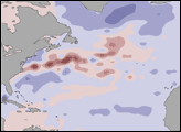
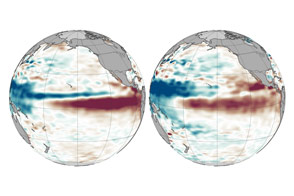
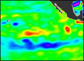
With each passing month, 2015 looks more and more like 1997.

Published Oct 13, 2015

Image of the Day Heat Water