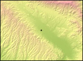
This topographic map of the South Island, New Zealand, illustrates the location of a large earthquake on September 4, 2010, how geologic activity shaped the region in the past, and why the current geology makes Christchurch vulnerable to earthquake damage.
Published Sep 7, 2010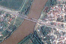
The day after a powerful 7.3-magnitude earthquake shook Honduras, Taiwan’s Formosat-2 satellite captured this detailed, photo-like image showing the collapsed span of the earthquake-damaged Democracy bridge.
Published Jun 3, 2009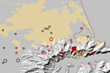
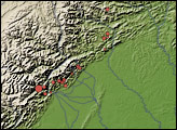
This map shows the location of earthquakes on near Christchurch, New Zealand between September 3, 2010, and February 22, 2011.
Published Feb 23, 2011
Sobering satellite views reveal massive damage on the Indonesian island of Sulawesi.
Published Oct 3, 2018Image of the Day Land Water Human Presence Remote Sensing Earthquakes