Images related to Topography of the Kunlun Fault

The Kunlun Fault
Image

The Kunlun Fault

Published Oct 10, 2000

Image of the Day Land

NASA Radar Provides 3-D View of San Andreas Fault
Image

NASA Radar Provides 3-D View of San Andreas Fault

Where the Pacific plate and North American plate meet, the intense pressure of the collision creates an 800-mile-long fracture zone.

Published Jun 23, 2009

Image of the Day Land Human Presence Remote Sensing

Earthquake in Central Italy
Image

Earthquake in Central Italy

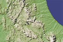
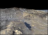
This image of central Italy shows the rugged topography in the vicinity of L’Aquila, where a magnitude 6.3 earthquake struck on April 6, 2009.

Published Apr 7, 2009

Image of the Day Land

Gulf Coast Land Elevation
Image

Gulf Coast Land Elevation

Published Sep 18, 2004

Image of the Day Land