

Every January through March, vast numbers of small fires spring up across the countryside in Southeast Asia. Those months usually bring cool, dry weather—perfect conditions for burning.
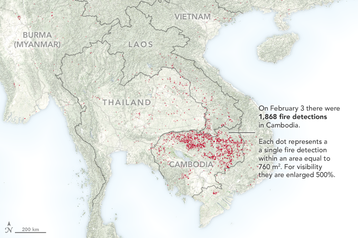
The Visible Infrared Imaging Radiometer Suite (VIIRS) on the Suomi NPP satellite captured data (above) showing the locations of hundreds of fires burning in Cambodia, Vietnam, Thailand, Laos, and Myanmar (Burma) on February 3, 2018. Each red dot on the map depicts one fire detection from the VIIRS 750-meter active fire data product. (Note that there is also a 375-meter active fire data product that detects more fires, but the 750-meter product is the basis for this useful mapping tool.)
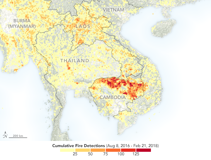
On that day, there were significantly more fires in Cambodia than in neighboring countries. VIIRS detected 1,868 hot spots in Cambodia, 185 in Laos, 77 in Myanmar, 217 in Thailand, and 114 in Vietnam. The large number of fires in Cambodia were the most VIIRS has observed on a single day in 2018. The pattern is consistent with recent years: As depicted in the map below, the instrument has detected four-to-five times as many fires in northern Cambodia as it did in Vietnam and Thailand between August 2016 and February 2018. Northern Laos also had a relatively high number of fires.


People light fires in Southeast Asia for several reasons. In some forested areas, small-scale subsistence farmers practice swidden agriculture (also called slash-and-burn). The technique involves cutting down trees and shrubs, letting the wood dry out for a few months, and then burning it to clear fields. Hunters sometimes start fires to drive reclusive animals into view. Likewise, people collecting mushrooms sometimes burn the forest floor to make it easier to forage. Loggers use fire to clear roads and to clear the land after harvesting the most desirable species. In non-forested areas, farmers set fires to dispose of plant debris after harvesting rice, wheat, and other crops. Discarded cigarettes, sparks from vehicles, and problems with electrical systems also spark fires.
The natural-color image (below) was acquired by the Operational Land Imager (OLI) on Landsat 8 on February 1, 2018, and shows fires burning in shrublands near a forested ridge in the Srepok Wildlife Sanctuary. Data collected by Landat’s Thermal Infrared Sensor (TIRS), overlain on the images in orange, shows where the sensor observed unusually warm land surfaces.
There are several reasons fire gets started in this particular area. Occasionally, lightning ignites dried vegetation. People use fire to harvest a prized type of resin from Dipterocarp trees and honey from bee hives. Sometimes those fires escape and spread. Timber harvesting is a known practice in this area, although the government of Cambodia has launched a campaign to stop it.
”Without having information from people on the ground, it usually isn’t possible to say definitively what caused a given fire when detected by a satellite,” said Evan Ellicott, a remote sensing and fire expert at the University of Maryland. “But it is quite clear that the total number of active fire detections made by satellites is linked to forest cover loss in Cambodia. Years with more fires have bigger losses in forest cover.”
The effects of all of these small fires can add up in other ways. With populations rising and the amount of farmland increasing, fires in Southeast Asia (including Indonesia and Papua New Guinea) are thought to be responsible for at least 10 percent—and likely significantly more—of global wildfire emissions, which can cause health problems and add greenhouse gases to the atmosphere.
NASA Earth Observatory images by Joshua Stevens, using fire data from the VIIRS Active Fire team and Landsat data from the U.S. Geological Survey. Story by Adam Voiland.