The Earth Observatory has published its last Image of the Day on this website. Please join us on our new home at science.nasa.gov/earth/earth-observatory.

In 2005, researchers at the Royal Botanic Gardens, Kew stumbled upon secret: a little-known forest in northern Mozambique. The researchers were looking for a site for a conservation project, and hoped to find a rainforest worth preserving. They found their treasure through Google Earth, in the form of a largely untouched rainforest atop Mount Mabu, surrounded by developed land. The scientists weren’t the only ones who knew of this forest; local villagers knew about it, but few citizens of Mozambique had heard of its existence. The forest’s remote location and value as a refuge for locals fleeing a 1975-1992 civil war saved it from development.
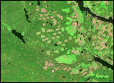
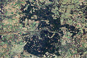
The Enhanced Thematic Mapper Plus on NASA’s Landsat 7 satellite captured this image of Mount Mabu on November 8, 2001. The deep green rainforest on Mount Mabu contrasts sharply with the surrounding land, where a patchwork of crops predominates. Croplands appear in varying shades of pale green, tan, and beige. Pockets of deep green are scatted throughout the developed area; these isolated remnants hint at the previous extent of the forest. Some of the cleared lands have a purplish color that could result from burning. Northwest of the mountain, a few puffs of blue-tinged smoke are visible.
Scientists at Kew concluded that a robust local economy, while good for human residents, threatened to degrade the forest of Mount Mabu through logging or agricultural burning. A series of expeditions to the rainforest uncovered pygmy chameleons, rare species of butterflies, a new snake species, three bird species not previously seen in the region, and a wealth of plant life, including rare orchids. Shortly after discovering the area, the Kew scientists began working with the government of Mozambique to protect the area.
NASA image created by Jesse Allen, using Landsat data provided by the United States Geological Survey. Caption by Michon Scott.