

A magnitude 6.4 earthquake hit the rural, mountainous region of southwestern Pakistan on October 29, 2008, at 4:09 a.m. local time (October 28 at 23:09 UTC). The quake and aftershocks caused building collapses and landslides northeast of the city of Quetta that killed at least 160 people and left at least 15,000 people homeless, according to reports from BBC news.
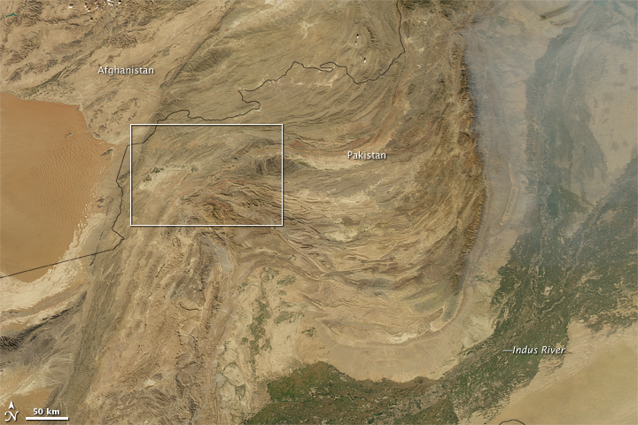
Pakistan is prone to earthquakes because it lies in the collision zone of the India tectonic plate to the south and the Eurasian plate to the north. (In October 2005, an even deadlier quake struck the Kashmir region, farther north.) This natural-color image of the area collected by the Moderate Resolution Imaging Spectroradiometer (MODIS) on NASA’s Aqua satellite shows the dramatic impact the collision has on the area’s topography. The image was captured on October 28 before the earthquake. The bottom image is a close-up of the area northeast of Quetta where the quake and aftershocks occurred (red circles).
The India plate is drifting generally northward and ramming into the Eurasia plate. The collision zone generally follows the belts of folded, parallel ridges and basins in eastern Afghanistan and western Pakistan. The area where the October 29 quake occurred seems to sit near a pivot point in different fold belts. South of the city of Quetta, the folded rocks line up generally north-south, but to the east, the mountains have been bent into a “U†shape. The shape is repeated in the southeast by the wide belt of vegetation (dark green) along the banks of the Indus River. The air is hazy at upper right; this is probably a mixture of smoke from agricultural fires and urban pollution from areas to the east.
NASA image created by Jesse Allen, using data obtained from the Goddard Land Processes data archives (LAADS). Earthquake data provided by the U.S. Geological Survey Earthquake Hazards program.