The Earth Observatory has published its last Image of the Day on this website. Please join us on our new home at science.nasa.gov/earth/earth-observatory.
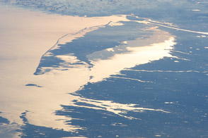
For decades, scientists have been intrigued by dark patches found within otherwise bright, gleaming areas visible in some astronaut photographs and satellite images of water. On May 6, 2023, the Moderate Resolution Imaging Spectroradiometer (MODIS) on NASA’s Aqua satellite captured this image of a dark area off the Delmarva Peninsula of the U.S. East Coast. The blue tendrils of a phytoplankton bloom, present since April, were also visible.
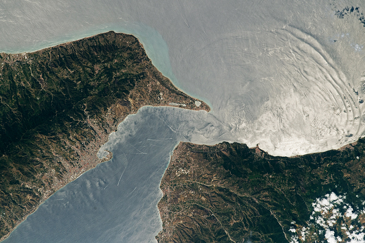
The bright, silvery appearance of much of the water is due to sunglint—an optical phenomenon that occurs when sunlight reflects off the surface of the water at the same angle that a satellite sensor views it. The result is mirror-like specular reflection that shows up as long, bright areas in MODIS data. Several areas of sunglint are apparent near the center of each swath of MODIS data shown below, acquired on July 3, 2014.
The “roughness” of the water surface can influence how sunglint areas appear in MODIS images—sometimes creating distinctive patterns within them. Most of the time, winds create enough waves and choppiness in the water that light gets reflected in a variety of directions (diffuse reflection) as it hits the sea surface. The complex geometry of wind-driven waves means that enough of that light happens to be directed toward the satellite sensor, giving sunglint areas their bright silvery appearance.
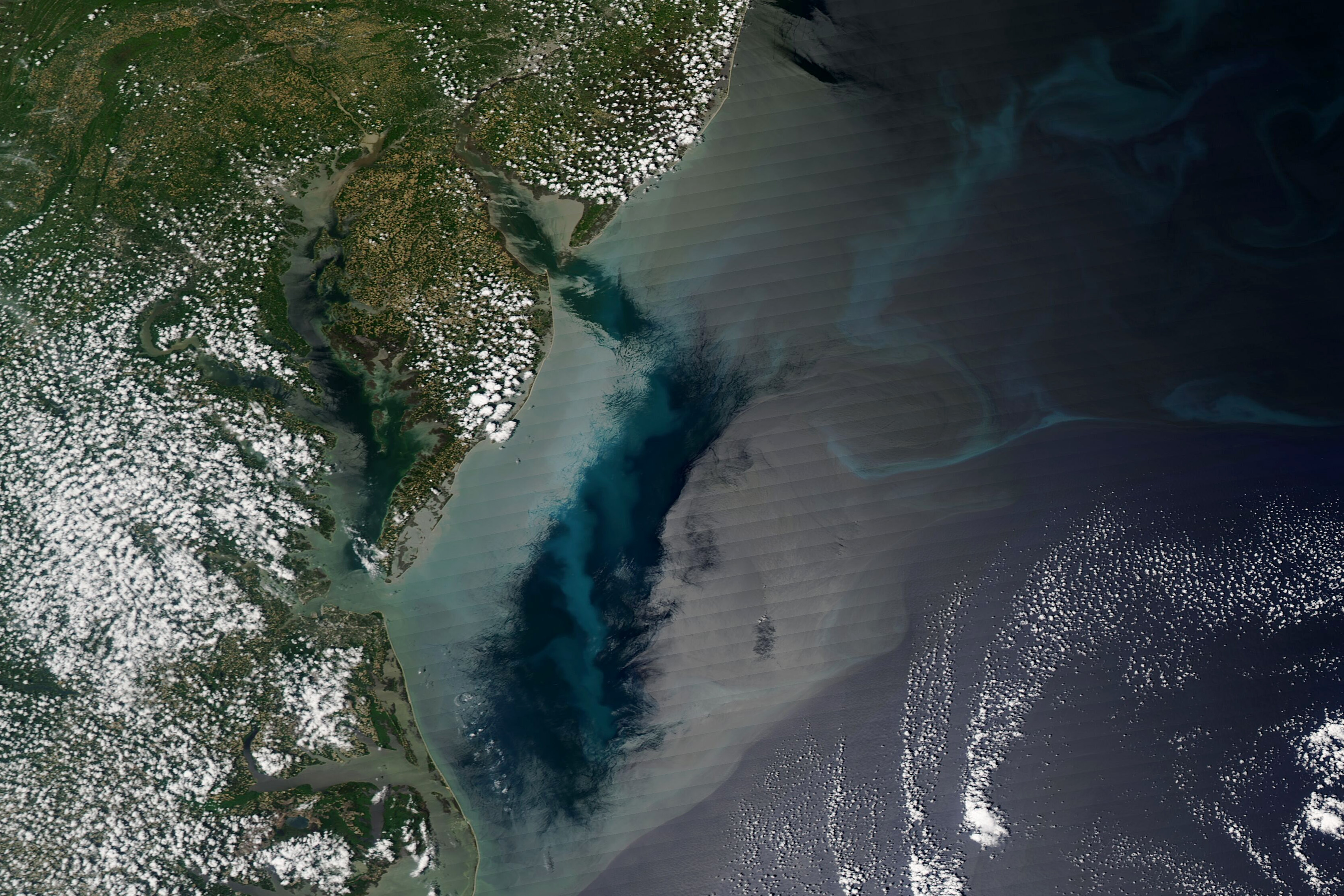
But an area with weak winds, as was the case east of the Delmarva Peninsula on May 6, 2023, the ocean surface was smooth and glassy, causing most of the light to be reflected in the same direction. If it is reflected directly toward MODIS, especially bright circular areas called specular highlights appear in the imagery. (The very bright area near the coast of Surt, Libya, on June 9, 2023, is an example of a specular highlight.) But if the light is reflected away from MODIS instead, dark patches can appear.
“Within a region of light winds, the appearance of the rather flat underlying water surface—either darker than adjacent water, or extremely bright—depends on the sun-satellite geometry,” explained Scott Bachmeier, a research meteorologist with the Cooperative Institute for Meteorological Satellite Studies at the University of Wisconsin-Madison.
“In this case, the dark features were likely areas with very weak winds,” said Chuanmin Hu, a professor of optical oceanography at the University of South Florida. “But other things that change the ‘roughness’ of the water can lead to changes in sunglint patterns as well. These include oil slicks, freshwater slicks, ship wakes, ocean circulation, internal waves, and ocean circulation.”
Hu added that freshwater slicks—possibly those containing colored dissolved organic matter (CDOM), phytoplankton, oil, or a variety of biogenic surfactants—could be contributing to the dark color in certain areas. “Some of the narrow dark features inside Delaware Bay and Chesapeake Bay may be partly due to freshwater, but freshwater slicks are not generally as large as the main dark patch visible east of the Delmarva Peninsula,” Hu said.
While sunglint often produces visually stunning images that are useful for inferring winds and detecting oil spills, the phenomenon can also create problems for remote sensing scientists because it can obscure features of interest. This is particularly true for oceanographers who use satellites to study phytoplankton and ocean color. As a result, researchers have developed several methods to correct for sunglint or screen sunglint-contaminated imagery out of ocean color data archives.
“One thing to keep in mind when looking at sunglint imagery is that the eye assesses brightness and color in context,” said Ralph Kahn, an atmospheric scientist at NASA’s Goddard Space Flight Center. “So a patch that looks dark might actually be quite bright, just significantly darker than adjacent parts of the scene.”
Brian Barnes, an oceanographer at the University of South Florida, added: “Engineers have also developed several sensor designs—including the Ocean Color Instrument (OCI) on the upcoming Plankton, Aerosol, Cloud, ocean Ecosystem (PACE) mission—that minimize sunglint by tilting.”
NASA Earth Observatory image by Wanmei Liang, using MODIS data from NASA EOSDIS LANCE and GIBS/Worldview. Story by Adam Voiland, with input and fact-checking by Ralph Kahn (NASA GSFC), Scott Bachmeier (University of Wisconsin-Madison/CIMSS), Scott Lindstrom (University of Wisconsin-Madison/CIMSS), Chuanmin Hu (University of South Florida), and Brian Barnes (University of South Florida).