
After several weeks of heavy rainfall in northern Queensland, floodwater has worked its way south into Australia’s Channel Country. By mid-January 2023, floodwater from the north had combined with local rainfall to cause rivers to overflow their banks.
The surge of water is visible in this false-color image (right), acquired on January 22, 2023, with the Moderate Resolution Imaging Spectroradiometer (MODIS) on NASA’s Terra satellite. Water appears light to dark blue; vegetation is green and bare land is brown. The left image, acquired with Terra MODIS on December 10, 2022, shows the same area prior to the flooding.
Australia’s Bureau of Meteorology reported major flooding along parts of the Georgina River, and moderate to major flooding along Eyre Creek, on January 23, 2023. Flooding along Eyre Creek near Bedourie was expected to peak on that day and remain above moderate flood levels (4 meters) for several days.
Several small, remote towns—including Bedourie—became isolated when floodwater submerged roads and cut off access to ground transportation. Food from a delivery truck on its way to Bedourie had to be moved into an airplane and flown into town.
But the abundant water can also bring benefits to the Lake Eyre Basin. Notice the green up in previously brown areas, where vegetation has taken advantage of the moisture. And on occasion, water from heavy rainfall events can flow all the way to Lake Eyre (Kati Thanda), providing a temporary desert oasis for birds and other wildlife.

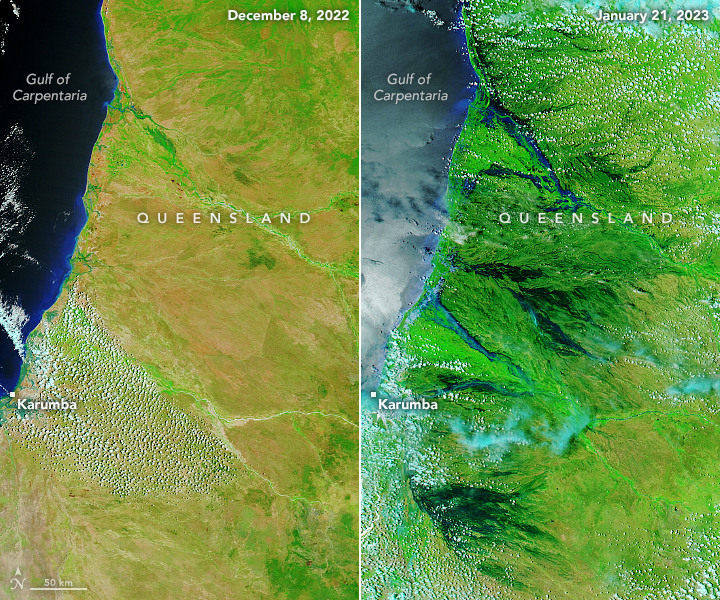
Yet as water flowed south, parts of northwest Queensland remained visibly flooded. MODIS on NASA’s Terra and Aqua satellites acquired these images before and after the rainfall, on December 8, 2022 (left), and January 21, 2023 (right), respectively. In this view, wetlands along the Carpentaria Coast are inundated with water.
The water cut off access to the remote town of Karumba. But it has also brought a green up to the wider area, which has been welcomed by farmers with livestock that graze on the region’s grasses.
NASA Earth Observatory images by Lauren Dauphin, using MODIS data from NASA EOSDIS LANCE and GIBS/Worldview. Story by Kathryn Hansen.