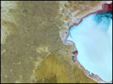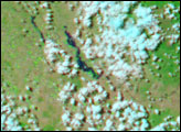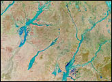

The northern monsoon brought a period of heavy rains to Queensland in northeast Australia over the past week to 10 days. A monsoon trough set up over the eastern third of the country and anchored by a persistent, monsoon low over the northern part of the Northern Territory pumped warm, humid air down from the Tropics into Queensland. This pattern produced heavy rains from the Gulf of Carpentaria along the northern coast of Queensland, across Queensland and down to the northeast coast of New South Wales.
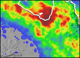
The TRMM-based, near-real time Multi-satellite Precipitation Analysis (MPA) at the NASA Goddard Space Flight Center monitors rainfall over the global tropics. MPA rainfall totals for the period January 9-20, 2004, reveal that coastal areas of the Northern Territory and Queensland along the Gulf of Carpentaria may have received well over a foot of rain (darker red areas). A widespread area of 5-inch totals (green areas) with locally heavier amounts of up to 10 inches (yellow and orange areas) extends southeastward across most of Queensland to the coast of New South Wales. The bulk of the heaviest rainfall totals along the northern coast fell between the 12th and 15th of January in association with the monsoon low, which eventually tracked southeastward and off the coast.
TRMM is a joint mission between NASA and the Japanese space agency JAXA.
Image produced by Hal Pierce (SSAI/NASA GSFC) and caption by Steve Lang (SSAI/NASA GSFC)
The northern monsoon brought heavy rains and floods to Eastern Australia.


