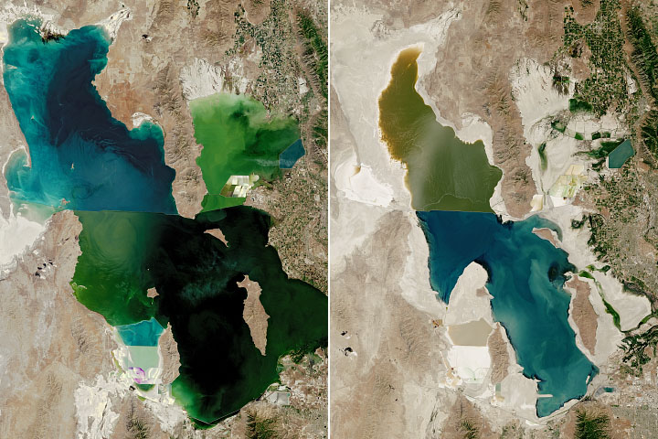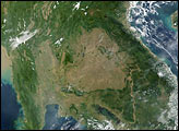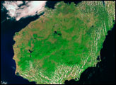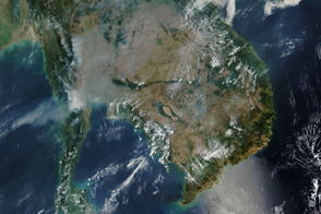
The wetlands of southern Cambodia are illuminated by sunglint in this panoramic photograph taken by an astronaut from the International Space Station (ISS). Large swaths of Southeast Asia—including Laos, Thailand, Burma (Myanmar), and Malaysia—fill the scene that looks to the south. Vietnam is mostly obscured by clouds on the southern and eastern edges of the peninsula.
Sometimes referred to as the Indochinese Peninsula or Indochina due to its geographic position between India and China, the region includes a mixture of fertile plains, tropical forests, mountain ranges, and urban areas (such as Bangkok). In the photo, sunlight reflects off of the Gulf of Thailand and the Tonle Sap floodplain, one of the region’s many marshes and wetlands.
The Mekong River flows down from the Tibetan Plateau and defines most of the border between Thailand and landlocked Laos. The river and its tributaries are a focal point around which human populations have settled and cultivated agriculture for centuries. The lower Mekong basin, transitioning from mountainous uplands to flat coastal lowlands, flows into the Gulf of Thailand and, ultimately, the South China Sea. It is through these waters that Mainland Southeast Asia is linked to Malaysia and Maritime Southeast Asia.
The tropical climate and the irrigation water provided by the river makes the peninsula well-suited for rice production. This staple crop has played a significant role in the cultural development and environmental change of the area. However, challenges to rice cultivation have increased in recent years due to extreme weather events such as droughts and floods.
Astronaut photograph ISS066-E-88446 was acquired on December 12, 2021, with a Nikon D5 digital camera using a focal length of 24 millimeters. It is provided by the ISS Crew Earth Observations Facility and the Earth Science and Remote Sensing Unit, Johnson Space Center. The image was taken by a member of the Expedition 66 crew. The image has been cropped and enhanced to improve contrast, and lens artifacts have been removed. The International Space Station Program supports the laboratory as part of the ISS National Lab to help astronauts take pictures of Earth that will be of the greatest value to scientists and the public, and to make those images freely available on the Internet. Additional images taken by astronauts and cosmonauts can be viewed at the NASA/JSC Gateway to Astronaut Photography of Earth. Caption by Alex Stoken, Jacobs, JETS Contract at NASA-JSC.