

Central America experienced one of its most intense hurricane seasons in 2020. Two major hurricanes and a handful of other late-blooming storms took many lives, displaced hundreds of thousands of people, and caused billions of dollars in economic losses. The storms also left severe scars on the landscape, particularly in some mangrove ecosystems.
Mangroves are networks of hardy trees and shrubs that typically grow in coastal wetlands. They are valuable because they help prevent coastal erosion, absorb carbon from the atmosphere, and provide habitat for fish and other marine animals. But recent hurricane seasons in Central America and Mexico have threatened some of these vulnerable wetland forests. Using satellite data and drone imagery, scientists from NASA and other international institutions have been evaluating mangrove damage from the 2020 hurricane season.
“Extreme events in the Caribbean are not new, but we are seeing more of them in recent years,” said Rosa Roman-Cuesta, a tropical forest ecologist at Wageningen University (The Netherlands). “We are trying to understand how coastal systems are responding to these events. That’s why studying the effect of the 2020 mega-hurricane season is important.”
Roman-Cuesta said the type of hurricane damage has evolved over the years. In years past, she explained, hurricane winds typically caused most of the mangrove damage by uprooting trees, defoliating entire areas, and blocking drainage to the ocean. But in recent years, storms have been rapidly intensifying and stalling more often. The result is extreme precipitation and flooding that affects oxygen concentrations in soils and hinders photosynthesis for mangroves. Large storm surges also physically damage the trees.
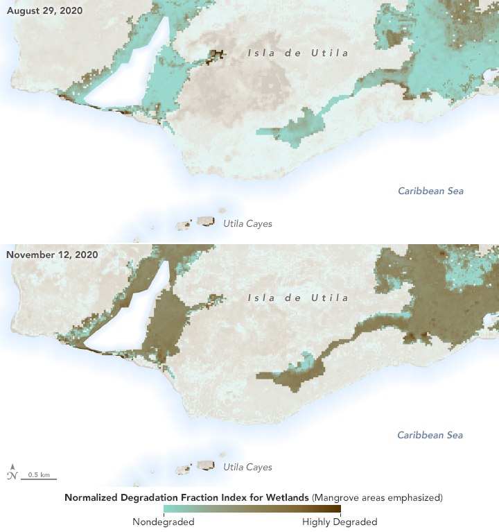
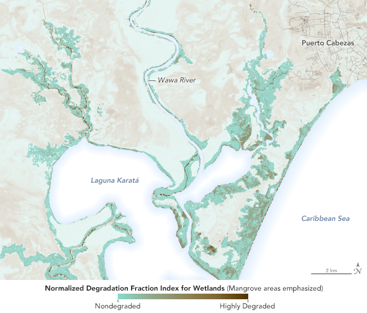
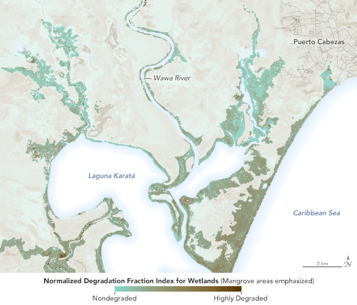
The maps above show mangrove degradation in Honduras and Nicaragua during the 2020 hurricane season. The degradation is shown using a Normalized Degradation Fraction Index (NDFI) for wetlands, measured by scientists at NASA’s Goddard Space Flight Center. This new version of the NDFI combines changes in the amount of bare soil exposed, water content, and greenness of vegetation before and after the hurricanes to create a damage assessment. The data come from the MultiSpectral Instrument (MSI) on the European Space Agency’s Sentinel-2 satellite. Past mangrove analyses only considered vegetation changes, while this damage measurement offers more dimensions to help researchers learn how and why the mangroves degraded.
The first image set (top) shows mangrove areas in the Karatá region of northeast Nicaragua on January 26, 2020 (left) and November 11, 2020 (right), shortly after Hurricane Eta made landfall with category 4 winds. Overall, the sampled areas experienced a 23 percent decrease in green mangrove vegetation after the storm. Data also indicated a lot of soil upheaval.
The second image pair shows mangroves on the island of Utila in northern Honduras on August 29, 2020 (top) and November 12, 2020 (bottom). The region saw a 27 percent decrease in mangrove vegetation. By the time Eta hit Honduras, the storm’s winds had decreased. Instead of soil upheaval, the data showed much higher content of water in the soil, suggesting more flooding damage.
“When we are analyzing the impact of a hurricane on a mangrove forest, the damage could be from wind, storm surge, or flooding from high rainfall,” said Cibele Amaral, a professor at Federal University of Viçosa (Brazil) and a visiting scientist at NASA Goddard. “Now, we can disentangle the different components and better understand the dynamics of the mangrove after a hurricane.”
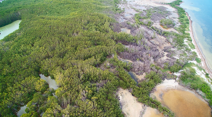
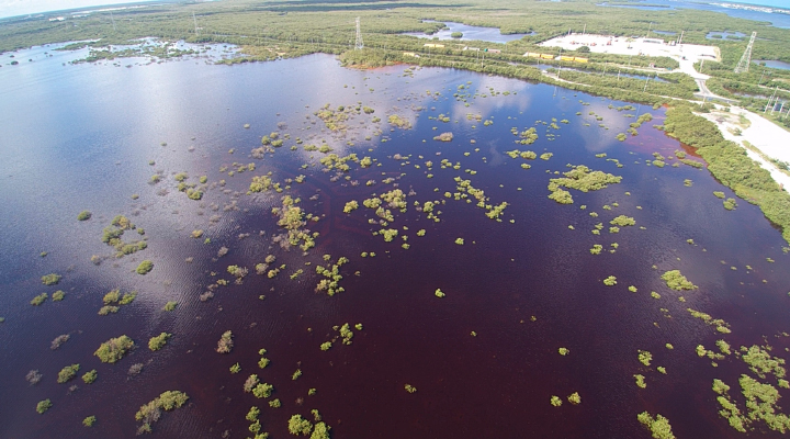
These drone images show mangrove damage in October 2020 in Yucatan, Mexico, after hurricanes Delta and Zeta passed through. The first image shows wind damage and defoliation in the municipality of Dzilam el Bravo, while the second image shows flooding near the city of Progreso. The images were provided by Jorge Herrera from the Center for Research and Advanced Studies of the National Polytechnic Institute (CINVESTAV) and his Yucatan-based team.
The research team believes the 2020 mangrove damage was likely compounded by lingering effects from recent hurricane seasons and other climate factors like droughts. Severe storms in 2017 caused nearly 30 times more mangrove damage than any of the previous eight hurricane seasons. NASA Goddard researchers Lola Fatoyinbo and David Lagomasino flew over the area in research planes and studied many of the heavily damaged areas. Mangroves can regrow and recover after such events, but it can take years even without the interruption of other extreme events.
“A hurricane’s impact today is going to be different from what it might have been 30 years ago because the resilience of these mangrove ecosystems has shifted in response to more extreme climate events,” said Ben Poulter, a researcher at NASA Goddard who was involved in the 2020 analysis.
The team will continue monitoring the damage via satellite and through fieldwork for at least the next two years in the COastal biodiversity RESilience to increasing extreme events in Central America (CORESCAM) project. Funded by BNP Paribas Foundation, CORESCAM brings together scientists from NASA, the Smithsonian Institution, the Audubon Society, East Carolina University, and international universities and research institutions to better understand how mangroves and coral reefs are responding to extreme climatic events. The team is working with local governments to provide data on which forests and reefs require extra conservation resources and to prioritize restoration action in the region.
NASA Earth Observatory images by Lauren Dauphin, using modified Copernicus Sentinel data (2020) processed by the European Space Agency and analyzed by Amaral, et al., data from OpenStreetMap, and Global Mangrove Watch (2016). Drone imagery courtesy of Jorge Herrera / Center for Research and Advanced Studies of the National Polytechnic Institute (CINVESTAV). Story by Kasha Patel.