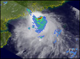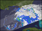
Unnamed tropical storm 02B came ashore along the northwest coast of Burma (Myanmar) on the May 19, 2004, bringing with it strong winds and heavy rains. The system formed in the northern Bay of Bengal on May 17, and moved east as a strong tropical storm with maximum sustained winds estimated at 60 knots (69 mph) by the Joint Typhoon Warning Center as it crossed the coast of Burma. The system came ashore near the port city of Sittwe not far from the border with Bangladesh.
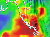
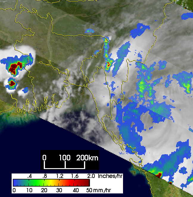
The Tropical Rainfall Measuring Mission (TRMM) satellite measures rainfall over the global tropics using both active and passive sensors. TRMM snapped this image of tropical storm 02B inland over Burma. Taken at 11:47 UTC on the 19th, it shows the horizontal distribution of rain intensity from the TRMM Precipitation Radar (PR) in the center swath and the TRMM Microwave Imager (TMI) in the outer swath overlaid on infrared (IR) data from the TRMM Visible Infrared Scanner (VIRS). The image shows that the system has weakened over land as the center of the storm is surrounded mainly by light (blue) to occasionally moderate (green areas) rain with the southern part nearly void of rain. Further south of the center, part of a more intense rain area (dark red) is visible in a rainband. The strong convective storms (dark red centers) well west of the tropical storm located just west of Bangladesh over India are not associated with the tropical storm.
TRMM is a joint mission between NASA and the Japanese space agency JAXA.
Image produced by Hal Pierce (SSAI/NASA GSFC) and caption by Steve Lang (SSAI/NASA GSFC).