For millennia, the river has been the most important water supply in the western Sahara Desert.
Published Oct 27, 2014
In the past few centuries, a river in northwestern Canada stopped wandering and assumed a more direct route to the sea.
Published Sep 4, 2012
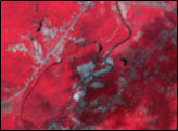
Acquired March 6, 2001, this false-color image shows Tombouctou (Timbuktu) and the surrounding region. Vegetation is red, water is blue, human-built structures are brown-gray, and bare ground ranges in color from off-white to tan.
Published Oct 11, 2009
Acquired May 1, 2011, this natural-color image shows the James River completely filling the river valley near Jamesville, South Dakota.
Published May 3, 2011
As they prepare for a satellite that will measure the height and areal extent of rivers in unprecedented detail, hydrologists have released a better map of North American river widths.
Published Jul 9, 2015
Floods and new infrastructure have long since separated the distinctive bend in the river that was portrayed by landscape painter Thomas Cole in 1836.
Published Oct 15, 2017
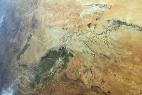
In Western Sahara, an unusual river vanishes in a sand field before it reaches the sea. In the process, it provides water for the largest city in the country.
Published May 9, 2016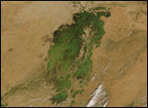
In the middle of Mali, part of the landscape gleams like a giant emerald in the otherwise arid brown African Sahel. The gleaming jewel is the Inland Niger Delta.
Published Nov 23, 2007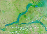

Trees have long been cherished here for timber and for the colors they bring to “the Fall Rhapsody.”
Published Oct 24, 2020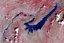
This false-color image shows the central part of the Vakhsh River, including the Nurek Dam and reservoir.
Published Nov 25, 2008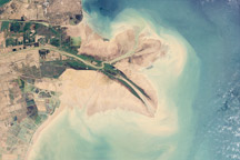
Chinese engineers changed the main channel through the delta, changing the shape of the land at the river’s mouth.
Published Jan 27, 2010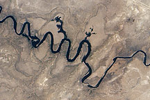
In September 2010, water again flowed through this riverbed after several dry years.
Published Oct 8, 2010alert message
