This hand-held astronaut photo shows urban areas and fault-related topographic features from San Bernardino, California, to Tijuana, Mexico.
Published Dec 15, 2008
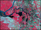
The longest river in Asia, the Yangtze River brings mixed blessings to China. Although it meets the water needs of millions of people, the river regularly overflows its banks. To protect residents and land in the lower Yangtze floodplains, China began construction on the Three Gorges Dam in 1994.
Published Jun 13, 2007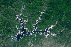
The Golden State’s largest reservoir has warmed and become depleted over the past decade.
Published Jun 26, 2015
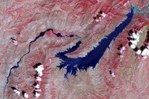
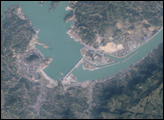
This false-color image shows the central part of the Vakhsh River, including the Nurek Dam and reservoir.
Published Nov 25, 2008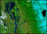
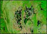
Northern California ushered in 2006 with a series of major storms that inundated the area and left many towns awash in water, mud, and debris. According to a report from the USATODAY.com Website, at least two levees in the Sacramento-San Joaquin Delta region were unable to handle the rising waters and strong winds, and residents nearby evacuated as the water-control structures began leaking. In the wine-country town of Napa perhaps as many as 1,000 homes were flooded along with thousands of acres of rural and agricultural land. The governor declared several counties in the region flood disaster areas.
Published Jan 6, 2006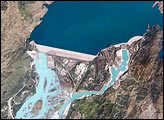
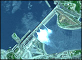
The Indus River basin extends from the Himalaya Mountains that form the northeastern boundary of Pakistan to the alluvial plains of Sindh near the Arabian Sea coastline. Tarbela Dam is part of the Indus Basin Project, which resulted from a water treaty signed in 1960 between India and Pakistan. This treaty guaranteed Pakistan water supplies independent of upstream control by India. Designed primarily for water storage rather than power generation, the dam was completed in 1977. Turquoise waters of the Indus River (to the south of the dam) reflect the high proportion of silt and clay suspended in waters released by the spillways.
Published May 30, 2005