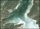
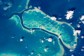
Chetumal Bay lies on the Border between Mexico and Belize. To the east of the bay, Ambergris Cay connects the Belize Barrier Reef to the Yucatan Peninsula. The north of the island is Bacalar Chico Marine Reserve. Here, the barrier reef comes very close to the east side of the island. In 1998, reefs in Belize were hit by two major events that led to heavy coral mortality: El Niño-related coral bleaching and Hurricane Mitch.
Published Oct 28, 2001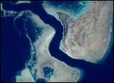
Studying corals from above could help scientists understand how these critical ecosystems will weather a changing climate.
Published Jan 31, 2016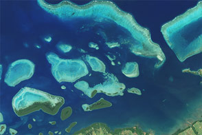
An image of Fiji’s coast shows how modern satellites can help study underwater corals even in the most remote regions.
Published Jul 4, 2015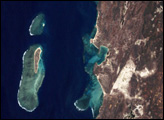
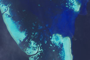
In February 2017, the Great Barrier Reef continued to be exposed to warm ocean water—the main stressor on this coral system and the reason for its bleaching.
Published Mar 16, 2017
The Great Barrier Reef is the largest reef system on Earth, with more than 3,000 separate reefs and coral cays. It is also one of the most complex natural ecosystems.
Published May 31, 2016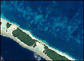
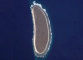
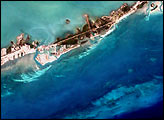
Howland Island is a United States possession located in the north Pacific between Australia and the Hawaiian Islands. Prior to 1890, organic nitrate (guano) was mined from the island by both the United States and the British. This tiny island (1.6 km²) is currently part of the U.S. National Wildlife Refuge system, and provides nesting areas and forage for a variety of birds and marine wildlife. The island is composed of coral fragments and is surrounded by an active fringing reef. White breakers encircling the island indicate the position of the reef. Astronauts aboard the International Space Station photograph numerous reefs around the world as part of a global mapping and monitoring program.
Published Jan 4, 2005
The Dominican Republic occupies the eastern two-thirds of the island of Hispaniola in the Caribbean Sea. The island has a variety of ecosystems ranging from arid plains to tropical rain forests created by three roughly parallel east-west mountain ranges. The northernmost of these ranges, the Cordillera Septentrional, is visible in this astronaut photograph as the dark green region north of the river. Clearcut regions within the Cordillera Septentrional are visible as irregular light green regions interspersed with dark green forested areas.
Published Aug 9, 2004