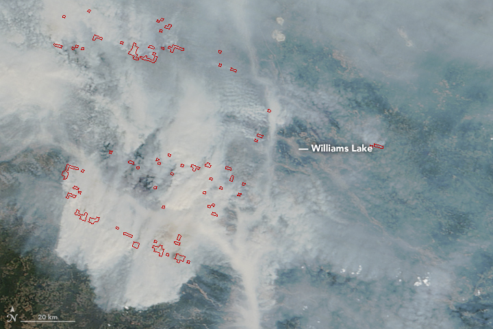


In July 2017, the forests of south-central British Columbia were primed to burn. Abnormally hot, dry weather had stressed vegetation and dried out the soil, and many forests were already full of dead trees because of infestations of mountain pine beetles. When lightning storms passed over the region on July 7, more than 100 fires were sparked.
Some of these fires are still raging. As of July 19, 2017, the British Columbia Wildfire Service reported 50 wildfires burning in the region managed by the Cariboo fire center and another 21 in the Kamloops fire center. The fires have charred roughly 300,000 hectares (1,000 square miles).
On July 18, 2017, the Moderate Resolution Imaging Spectroradiometer (MODIS) on NASA’s Terra satellite captured these images of smoke blanketing the region. Actively burning areas, detected by MODIS’s thermal bands, are outlined in red. As smoke spread across the region, Environment Canada issued air quality advisories for large parts of British Columbia and Alberta provinces.
Intense burning fueled pyrocumulus clouds, which loft smoke high into the atmosphere and allow higher-level, fast-moving winds to transport it long distances. Colin Seftor, an atmospheric scientist based at NASA's Goddard Space Flight Center, has published data maps collected by the Ozone Mapping Profiler Suite (OMPS) that show the smoke reaching as far as the U.S. Midwest and northern Quebec.
The fires have forced nearly 50,000 people to evacuate their homes, according to news reports. Among them is Williams Lake, a town of 10,000 people. Authorities evacuated the lakefront community on July 16 as fires approached, and it looked possible that fires could force the closure of critical roads. The number of people displaced in British Columbia rivals the fires of 2003, when roughly 50,000 people had to evacuate after a flare-up near Kelowna.
NASA images by Jeff Schmaltz, LANCE/EOSDIS Rapid Response. Story by Adam Voiland.