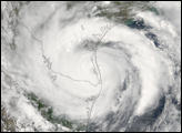
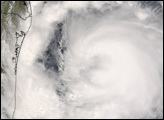
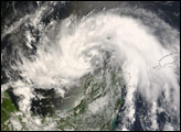
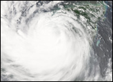
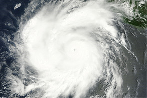
Hurricane Dolly intensified to a Category 2 storm in the Gulf of Mexico on July 23, 2008, just before it bore down on South Padre Island off the South Texas coast. At its strongest, the storm’s winds reached sustained speeds of 100 miles per hour, with higher gusts. As of the 2:00 p.m. (Central Daylight Time) advisory from the National Hurricane Center, Dolly had weakened to a Category 1 storm because part of the circulation was over land; winds were about 95 miles per hour.
This natural-color image of Hurricane Dolly was captured at 2:50 p.m. local time (19:50 UTC) by the Moderate Resolution Imaging Spectroradiometer (MODIS) on NASA’s Aqua satellite.
Dolly was the fourth named storm of the 2008 Atlantic hurricane season. It formed in the Caribbean Sea on July 20, weakened as it crossed the Yucatan Peninsula, and re-emerged in the Gulf of Mexico on July 21. The storm was predicted to continue inland on Wednesday afternoon and evening. According to the 2:00 p.m. NHC advisory, “Dolly is expected to produce total rainfall accumulations of 8 to 12 inches… with isolated amounts of 20 inches… over portions of South Texas and northeastern Mexico over the next few days. These rains will likely cause widespread flooding…. Coastal storm surge flooding of 6 to 8 feet above normal tide levels… along with large and dangerous battering waves… can be expected near and to the north of where the center makes landfall.”
NASA image created by Jesse Allen, using data provided courtesy of the University of Wisconsin’s Space Science and Engineering Center MODIS Direct Broadcast facility. Caption by Rebecca Lindsey.