

After a two-week period without any named storms, the 2011 Atlantic hurricane season revived in late October with the arrival of Hurricane Rina. The storm, which began as a tropical depression on October 23 in the western Caribbean, is adding misery and destruction to a region that has been battered by heavy rain and flooding events.
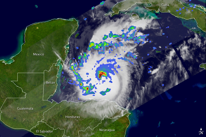
The Tropical Rainfall Measuring Mission (TRMM) collected these images of Rina at 8:06 Universal Time (3:06 am Central Daylight Time) on October 26, 2011, while located about 200 miles (330 kilometers) east of Belize. The top image shows a nadir, or straight down, view of rain intensities within Rina. Rain rates in the center of the field of view (or swath) are measured by the TRMM Precipitation Radar (PR). Those in the outer edges of the swath come from the TRMM Microwave Imager (TMI). Rain rates are overlaid on visible and infrared data from the TRMM Visible Infrared Scanner.
TRMM observed an area of intense rain (darkest reds) just north of the storm's eye wall. The south side of the eye wall is mostly absent of rain. In fact, beyond the northern eye wall, most of the rain is contained in a couple of bands far from the center (scattered blue and green areas indicating light and moderate rain, respectively).
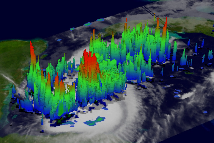
The second image shows a three-dimensional view of Rina. The areas in red are the tops of convective towers (hot towers), where precipitation-sized particles have been carried high into the atmosphere by strong updrafts within thunderstorms. TRMM shows several towers near the center and in the outer rain bands, with some standing taller than 15 kilometers. The heat released within these updrafts—mainly from condensation—is what drives tropical cyclones and their intensity.
At the time of these images, Rina was a Category 2 storm on the Saffir-Simpson scale—with sustained winds of 95 knots (110 miles per hour)—and it seemed poised to intensify. Shortly afterward, Rina's central pressure fell slightly, but then the storm weakened to a Category 1, with maximum sustained winds of 85 mph. The small size of the storm means it can quickly become vulnerable to changing environmental conditions.
Like many storms that form later in the season, Rina was influenced by a mid-latitude front that penetrated into the warm waters of the tropics. These fronts provide a focus for showers and thunderstorms that can eventually evolve into a tropical cyclone. During the peak of hurricane season in late August and September, many storms form from atmospheric waves moving off the coast of Africa into the tropical Atlantic. By mid-October, the focus tends to shift to the western Caribbean.
The TRMM satellite is a joint mission between NASA and the Japanese space agency, JAXA. Launched in November 1997, TRMM’s primary mission is to measure rainfall from space using a combination of both passive microwave and active radar sensors. TRMM has also proven to be a valuable platform for observing tropical cyclones.
Image produced by Hal Pierce (NASA GSFC) and caption by Steve Lang (NASA GSFC).