Seasonal variations in precipitation, sunlight, and temperature cause the wetness of the Earth’s land surfaces to change throughout the course of the year. Weather patterns and climate, which vary from year to year, cause similar changes in the amount of water stored on land. Terrestrial water storage includes groundwater, soil moisture, lakes and streams, snow, ice, and glaciers. These sources of freshwater are essential for domestic use, irrigation, industry, and life in general, so knowledge of water storage conditions—droughts, floods, or somewhere between—is precious. Until recently, water storage could only be measured using ground-based observations, of which there are fewer than necessary to develop regular, accurate assessments. Numerical models of the land surface, which are similar to weather forecasting models, fill part of the void. These models ingest satellite-based observations of rainfall and vegetation along with other data in order to generate maps of soil moisture, snow, and so on, using our understanding of the physics of the Earth’s water cycle.
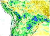
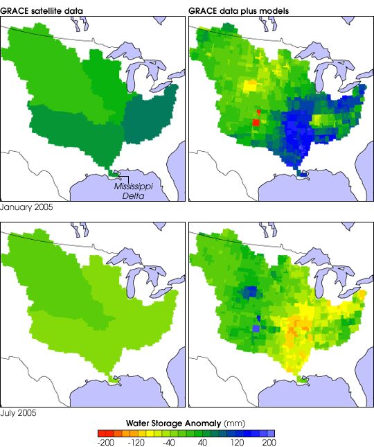
In 2002, NASA’s Gravity Recovery and Climate Experiment (GRACE) satellites began measuring variations in Earth’s gravity field with extremely high precision. Because gravity depends on mass, changes in the mass of water in a place produces detectable changes in Earth’s average gravity field. Based on GRACE measurements, we can derive changes in terrestrial water storage over large regions (greater than 200,000 square kilometers). This panel of images shows how terrestrial water storage in the four major sub-basins of the United States’ Mississippi River basin differed from average in January (top row) and July (bottom row) 2005.
The anomalies GRACE observed are shown as equivalent height of water in millimeters. In other words, if all of the water in and on the land surface existed as a lake of uniform depth, the color bar indicates by how many millimeters the lake level would have varied above (greens and blues) and below (yellows and reds) average. The GRACE observations alone (left column) are valuable for studies of climate variability and the global water cycle, but their coarse level of surface detail and the monthly frequency limit their usefulness for practical applications like predicting local irrigation demand or flood potential.
Using an advanced mathematical technique known as data assimilation, hydrologists are now combining GRACE data with numerical land surface models in order to produce the best possible maps of terrestrial water storage. The results (right column) combine the accuracy of GRACE data with the finer detail and more frequent updates of the models. Furthermore, while GRACE can only provide information on the total water stored in the whole basin, the assimilated model output separates terrestrial water storage into its primary components: groundwater, soil moisture, and snow.
Images created by Ben Zaitchik and Matt Rodell, Hydrological Sciences Branch, NASA Goddard Space Flight Center.