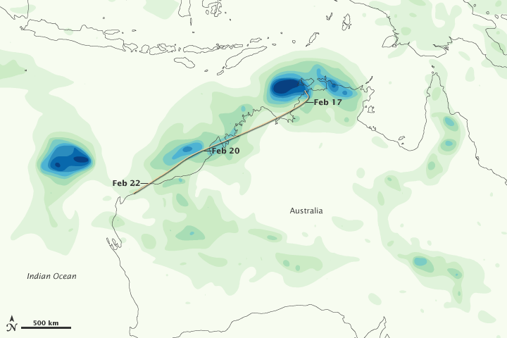


Tropical Cyclone Carlos brought heavy rains to the coasts of Northern Territory and Western Australia in February 2011. In the Northern Territory city of Darwin, Carlos helped break rainfall records in what was already an unusually rainy month. The storm’s high winds and heavy rains also forced the suspension of petroleum and mining projects in Western Australia, according to news reports.
This color-coded image shows rainfall amounts along the northwestern coast of Australia from February 15 to 22, 2011. The heaviest rainfall amounts—400 millimeters or nearly 16 inches—appear in dark blue. The lightest amounts—50 millimeters or less than 2 inches—appear in light green. The storm track for Carlos is superimposed on the rainfall amounts. Carlos maintained a fairly uniform storm intensity from February 17 to 22.
The U.S. Navy’s Joint Typhoon Warning Center (JTWC) reported that, as of 11:00 p.m. Western Australia time on February 22, Carlos was located roughly 100 nautical miles (185 kilometers) east-northeast of Learmonth, Western Australia. The storm had maximum sustained winds of 55 knots (100 kilometers per hour) and gusts up to 70 knots (130 kilometers per hour). Carlos was forecast to maintain its current strength over the next 12 hours then move west of Learmonth and intensify slightly. The storm was not expected to transition to an extra-tropical storm for about 96 hours.
This image is based on data from the Multisatellite Precipitation Analysis produced at Goddard Space Flight Center, which estimates rainfall by combining measurements from many satellites and calibrating them using rainfall measurements from the Tropical Rainfall Measuring Mission (TRMM) satellite.
NASA Earth Observatory image by Jesse Allen, using near-real-time data provided courtesy of TRMM Science Data and Information System at Goddard Space Flight Center. Caption by Michon Scott.