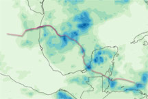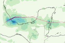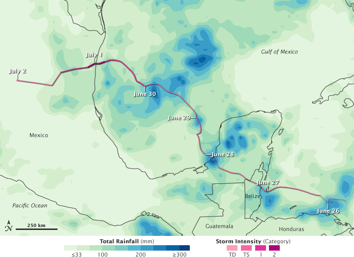

The first named storm of the 2010 Atlantic hurricane season, Alex strengthened to a hurricane before making landfall in northeastern Mexico. Between late June and early July, the storm dropped heavy rain over Central America, Mexico, and the Gulf of Mexico.
This color-coded image shows rainfall amounts from June 26 to July 2, 2010. The lightest rainfall amounts (less than 33 millimeters or about 1 inch) appear in pale green. The heaviest amounts (more than 300 millimeters or about 12 inches) appear in dark blue. The heaviest rainfall amounts appear over parts of Central America, the Yucatán Peninsula, and the Gulf of Mexico.
Superimposed on the rainfall amounts is a storm track for Alex. Darker shades of pink indicate greater storm strength. Alex reached hurricane strength before making landfall in Mexico and dissipating.
Although rainfall amounts appear relatively light in northeastern Mexico in this image, the storm caused substantial flooding, according to news reports. Floods caused particular damage in the city of Monterrey, swamping homes with mudslides, washing away parts of roads, sweeping away cars, even sweeping away buffalo from the city zoo. Reuters reported that Alex caused six deaths in Monterrey, as well as 12 deaths in Central America.
This image is based on data from the Multisatellite Precipitation Analysis produced at Goddard Space Flight Center, which estimates rainfall by combining measurements from many satellites and calibrating them using rainfall measurements from the Tropical Rainfall Measuring Mission (TRMM) satellite.
NASA Earth Observatory image by Jesse Allen, using near-real-time data provided courtesy of TRMM Science Data and Information System at Goddard Space Flight Center. Caption by Michon Scott.