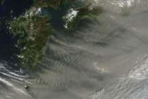

The first day of spring brought a massive sandstorm to China. The sand and dust were swept thousands of kilometers south and east from the arid terrain of Inner Mongolia. The yellow dust reduced visibility and air quality to potentially hazardous levels in the nation’s capital (Beijing), and as far away as Taiwan and Japan.
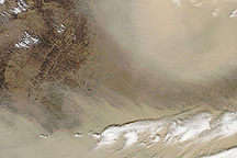
This natural-color image from the Moderate Resolution Imaging Spectroradiometer (MODIS) on NASA’s Terra satellite shows the dust storm on Saturday, March 20, 2010. Few landmarks or topographic features are recognizable beneath the dust, which covers the lower half of the image and wraps around the right-hand side in a comma shape that terminates in a large ball of dust near image center.
This pattern is consistent with the passing of a cold weather front bearing a strong area of low pressure at the surface. These weather systems, known as mid-latitude cyclones, are often associated with giant comma-shaped clouds that reveal how air from a very wide area gets drawn in toward the low-pressure heart of the storm. The comma shape is more pronounced in the large version of the image.
NASA image courtesy the MODIS Rapid Response Team. Caption by Rebecca Lindsey.
A huge sandstorm arrived in China on the first day of spring in 2010. Dust spread over the Korean Peninsula and Japan as the storm progressed.

