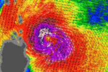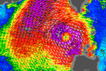

Typhoon Lupit continued heading toward the Philippines on October 22–23, 2009. QuikSCAT collected these wind measurements at 5:47 p.m. Manila time (09:47 UTC) on October 22, 2009. Wind speeds are color coded with the strongest winds, shown in pink and purple, occurring near the center of the storm. Barbs indicate wind direction.
QuikSCAT monitors wind speed with a radar that sends out pulses of microwave energy and listens for the echo after the pulse bounces off the wind-roughened ocean surface. Scientists translate radar signals into estimates of wind speed by matching the radar echoes to physical measurements collected from buoys at the same time and place.
Cyclone-strength wind speeds are rare, however, and scientists generally don’t have enough matching buoy observations to convert wind speeds above roughly 50 knots. Intense rain rippling the ocean’s surface can also interfere with the radar signal. Because of these limitations, QuikSCAT images don’t show absolute, maximum wind speeds. Instead, they give forecasters a valuable picture of the wind structure within the storm, for example, revealing whether a storm has a strong or a weak eye and how large an area is experiencing tropical-storm-strength winds.
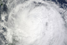
As of 5:00 a.m. October 23 Manila time (21:00 October 22 UTC), Typhoon Lupit was roughly 285 nautical miles (approximately 530 kilometers) north-northeast of Manila, continuing its westward path in the direction of the island nation, according to the U.S. Navy’s Joint Typhoon Warning Center. At that time, Lupit had maximum sustained winds of 65 knots (120 kilometers) with gusts up to 80 knots (150 kilometers per hour).
NASA image courtesy of David Long, Brigham Young University, on the QuikSCAT Science Team, and the Jet Propulsion Laboratory. Caption by Michon Scott, NASA Earth Observatory.