

large images:
United States
Northeast
West Nile Virus, first reported in the United States in 1999, causes flu-like symptoms that may lead to fatal encephalitis in people with compromised immune systems, such as the elderly. Though not yet proven, scientists believe the disease may be spread across the country by infected birds traveling along their migration routes. Mosquitoes that act as a vector carry the virus and pass it on when feeding on hosts like birds, livestock, other animals, and people.
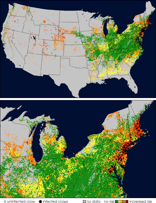
The above image is a West Nile Virus sample risk map for the United States derived from NASA satellite data and disease control data from the Center for Disease Control and state health departments. The small circles on this map represent uninfected crows reported in 2001. Black dots indicate infected crows, while larger dots reflect a higher concentration of infected crows in one area. The colors on this map represent relative levels of risk for West Nile Virus in 2001 as determined by scientists with NASA’s International Research Partnership for Infectious Diseases (INTREPID).
Researchers with INTREPID have been developing information products and databases derived from satellite data to show nationwide temperatures, distributions of vegetation, bird migration routes, and areas pinpointing reported cases. The combined data help scientists predict disease outbreaks by showing when and where habitats are suitable for the insects to thrive and where the disease appears to be spreading.
INTREPID falls under the umbrella of NASA’s Public Health Applications Program, which focuses the results of research occurring at different NASA centers. The program is designed to eventually supply public health agencies with access to NASA’s cutting-edge capabilities in formats they can use to better understand how and where West Nile Virus spreads, focus resources, and stave off the disease more efficiently.
For more information on NASA’s involvement with the virus, see NASA Researchers Developing Tools To Help Track and Predict West Nile Virus.
Images courtesy International Research Partnership for Infectious Diseases