Located in southeastern Alaska, the Columbia Glacier descends from the flanks of the Chugach Mountains and flows into a narrow inlet connected to Prince William Sound.
Prior to 1980, the glacier was generally stable. This photo from 1957 shows it reaching all the way to Heather Island.
It held a similar position in this aerial photo shot in 1969.
But in 1980, the glacier began to retreat, likely triggered by climate change. It became one of the fastest shrinking glaciers in the world.
Satellite images from the long-running Landsat program have documented the retreat.
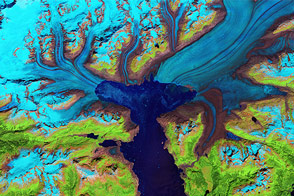
This natural-color image shows the glacier as your eyes would see it.
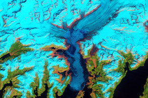
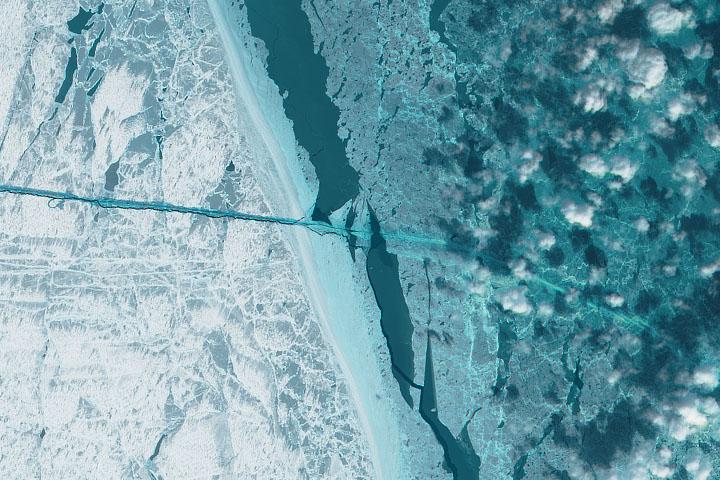
But false-color images can help differentiate between snow and ice, open water, vegetation and exposed bedrock, and rocky debris on the glacier’s surface.
This series of false-color images, acquired over the span of 35 years, shows the glacier’s dramatic retreat as well as some key moments along the way.
1986: Six years into Columbia’s retreat, the glacier had withdrawn more than a mile from Heather Island.
1989: At this point, the glacier still had three branches: the West Branch, Main Branch, and a sliver of ice that flowed east of Great Nunatak Peak.
1995: In some years, patches of lighter colored ice float south of the glacier. This mixture, or “mélange,” consists of sea ice mixed with icebergs that have broken from the glacier.
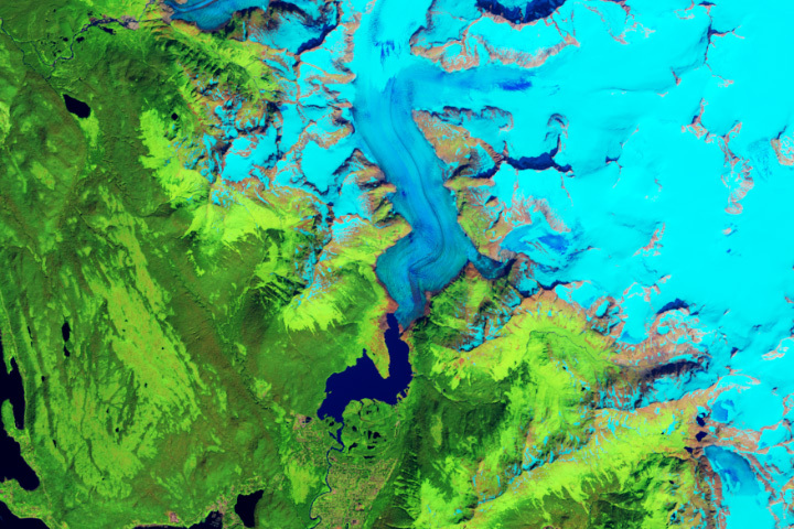
1997: Notice the medial moraine—a line of debris deposited along the ice surface that shows where separate channels of ice merged.
2000: As Columbia Glacier thinned, rings of freshly exposed rock, known as trimlines, became prominent around the inlet.
2001-2006: The retreat stalled until 2006, when the glacier became constricted by peaks on either side of the channel.
2008: Then, as the glacier’s front retreated into deeper water, it began to float.
2009: As a result, larger chunks of ice started to break off.
2011: By 2011, Columbia’s West and Main branches had split. Icebergs now calved from two distinct fronts.
2013: The West Branch took a large step backward in 2013, surprising scientists who thought it had stabilized.
2014: The Main Branch became increasingly unstable when thinning caused the glacier to lose traction with the floor of the inlet.
2019: Amid a hot summer, the West Branch appeared close to the limit of its retreat.
2021: Continuing to crumble away, the Main Branch in 2021 had retreated about 15 miles from its initial position.
While climate change likely started the retreat, mechanical processes kept the disintegration going.
Tidewater glaciers tend to cycle between periods of slow advance and rapid retreat. What Columbia Glacier will do next remains to be seen.
NASA images by Jesse Allen, Robert Simmon, Joshua Stevens, and Lauren Dauphin using data from Landsat 4, 5, 7, and 8 from the U.S. Geological Survey, and data from MODIS on NASA’s Terra satellite. Landsat program timeline by NASA’s Scientific Visualization Studio. Photos by William Osgood Field and Austin Post, from the National Snow and Ice Data Center’s glacier photograph collection. Music, “Icelandic Arpeggios,” by DivKid. Video and narration by Kathryn Hansen.
Watch the glacier crumble away as it retreats about 15 miles from its initial position in the 1980s.
Image of the Day for February 10, 2022
View more Images of the Day:

alert message